IMAGES TAKEN NEAR TO
Rutland Road, NOTTINGHAM, NG13 8DT
Introduction
This page details the photographs taken nearby to Rutland Road, NG13 8DT by members of the Geograph project.
The Geograph project started in 2005 with the aim of publishing, organising and preserving representative images for every square kilometre of Great Britain, Ireland and the Isle of Man.

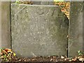
There are currently over 7.5m images from over14,400 individuals and you can help contribute to the project by visiting https://www.geograph.org.uk
Image Map
Images are licensed for reuse under creativecommons.org/licenses/by-sa/2.0
Notes
- Clicking on the map will re-center to the selected point.
- The higher the marker number, the further away the image location is from the centre of the postcode.
Image Listing (89 Images Found)
Images are licensed for reuse under creativecommons.org/licenses/by-sa/2.0
Image
Details
Distance
2
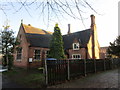
Old Church House, Bingham
Built as a school and schoolhouse. Scott and Moffatt 1845. https://historicengland.org.uk/listing/the-list/list-entry/1258810
Image: © Jonathan Thacker
Taken: 4 Dec 2019
0.07 miles
3
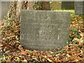
Belvoir Angel headstone, Bingham Churchyard
To Mary, wife of William Stevenson, d.1721. Listed Grade II together with that of (?son) William http://www.geograph.org.uk/photo/5168130 .
Image: © Alan Murray-Rust
Taken: 23 Oct 2016
0.07 miles
4
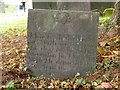
Belvoir Angel headstone, Bingham Churchyard
To William Stevenson, son of William and Mary, d.1707. Listed Grade II together with that of (?mother) Mary http://www.geograph.org.uk/photo/5168132
Image: © Alan Murray-Rust
Taken: 23 Oct 2016
0.07 miles
5
Belvoir Angel headstone, Bingham Churchyard
To Thomas Whates, d.1709
Image: © Alan Murray-Rust
Taken: 23 Oct 2016
0.07 miles
6
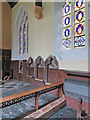
Bingham: All Saints - piscina, sedilia and Victorian glass
The piscina and sedilia date from about 1300. In the Second Edition of Pevsner's Nottinghamshire guide, Elizabeth Williamson describes the chancel glass as "Very pretty, probably of c 1873, with small figures and groups in medallions by Mrs Miles (d 1884) of Bingham".
Image: © John Sutton
Taken: 27 Jun 2017
0.07 miles
7
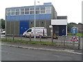
Bingham Telephone Exchange (2)
This photo shows the TE with its BT warning notice and yellow grit salt bin by its entrance, and a microwave dish fixed on its roof. To the right of the photo can be seen a blue one way sign and a triangular school road sign although the school adjacent to the TE would appear to be disused. The numbering range of this TE is (01949) 83xxxx, the (01949) referring to the Whatton group of TEs, and its postcode is NG13 8DQ.
Image: © David Hillas
Taken: 2 Sep 2013
0.07 miles
8
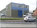
Bingham Telephone Exchange (1)
Situated at the corner of East Street and Fosters Lane, this TE is of a standard design dating from the early 1970s and would have replaced a smaller building from the GPO era in the same village. Besides Bingham, this TE serves Saxondale nearby. BT Openreach vans can be seen in front and at the side of this TE. They would be parked there whilst the BT engineers work inside this building.
Image: © David Hillas
Taken: 2 Sep 2013
0.07 miles
10
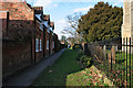
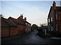
Church Lane, Bingham
To the west of the parish church.
Image: © Kate Jewell
Taken: 16 Mar 2010
0.07 miles