IMAGES TAKEN NEAR TO
Starbuck Gardens, NG13 7BX
Introduction
This page details the photographs taken nearby to Starbuck Gardens, NG13 7BX by members of the Geograph project.
The Geograph project started in 2005 with the aim of publishing, organising and preserving representative images for every square kilometre of Great Britain, Ireland and the Isle of Man.

There are currently over 7.5m images from over14,400 individuals and you can help contribute to the project by visiting https://www.geograph.org.uk
Image Map
Images are licensed for reuse under creativecommons.org/licenses/by-sa/2.0
Notes
- Clicking on the map will re-center to the selected point.
- The higher the marker number, the further away the image location is from the centre of the postcode.
Image Listing (8 Images Found)
Images are licensed for reuse under creativecommons.org/licenses/by-sa/2.0
Image
Details
Distance
1
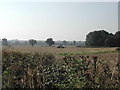
Preparing the land
land belonging to Foss Farm, near Bingham
Image: © Tom Courtney
Taken: 31 Aug 2005
0.12 miles

3
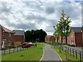
Walkway near Penson Gardens
This whole area has developed significantly over recent years and is still marked as open fields on the 2008 map I was carrying.
Image: © Jonathan Clitheroe
Taken: 13 Jul 2024
0.16 miles


6
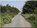
Chapel Lane (disused), Bingham
well it's used by "Fly Tippers"
Image: © Tom Courtney
Taken: 31 Aug 2005
0.18 miles
7
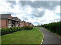
Walkway Alongside Cowdell Grove
This whole area has developed significantly over recent years and is still marked as open fields on the 2008 map I was carrying.
Image: © Jonathan Clitheroe
Taken: 13 Jul 2024
0.20 miles
8
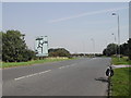
Road sign and Island
the island was built near the remains of Margidvnvm, a roman town
Image: © Tom Courtney
Taken: 31 Aug 2005
0.22 miles