IMAGES TAKEN NEAR TO
Kettleband Close, NOTTINGHAM, NG13 7AX
Introduction
This page details the photographs taken nearby to Kettleband Close, NG13 7AX by members of the Geograph project.
The Geograph project started in 2005 with the aim of publishing, organising and preserving representative images for every square kilometre of Great Britain, Ireland and the Isle of Man.

There are currently over 7.5m images from over14,400 individuals and you can help contribute to the project by visiting https://www.geograph.org.uk
Image Map
Images are licensed for reuse under creativecommons.org/licenses/by-sa/2.0
Notes
- Clicking on the map will re-center to the selected point.
- The higher the marker number, the further away the image location is from the centre of the postcode.
Image Listing (20 Images Found)
Images are licensed for reuse under creativecommons.org/licenses/by-sa/2.0
Image
Details
Distance
1
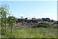
Romans Quarter housing development, Bingham
An extensive housing development of over 300 houses on former farmland between the old A46 and Chapel Lane. The name is derived from the nearby Roman settlement of Margidunum.
Image: © Alan Murray-Rust
Taken: 14 May 2020
0.04 miles
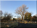
2
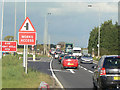
Works Access
This section of the A46 is being upgraded to dual carriageway, and the visible traffic flows indicate why this is being done. Part of the former RAF Newton has been taken over by the contractors for the project office.
Image: © Alan Murray-Rust
Taken: 23 Oct 2009
0.05 miles
3
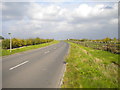
South end of Main Street, Newton
Alongside the A46 (the other side of the fence on the right).
Image: © Richard Vince
Taken: 15 Oct 2016
0.08 miles
4
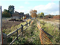
Footpath to Newton
The works at the left are part of the reconstruction of the A46 to dual carriageway form. Many of the footpaths abutting onto the A46 in the district are subject to temporary closures, but this one is not so affected. Its usability is however significantly curtailed.
Image: © Alan Murray-Rust
Taken: 23 Oct 2009
0.10 miles
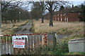
5

Former RAF Newton
Sentry box and empty houses at former RAF Newton
Image: © Richard Croft
Taken: 24 Oct 2008
0.11 miles
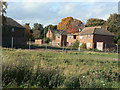
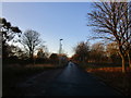
6
Newton Gardens
Formerly lined with officers' housing for RAF Newton. The housing was allowed to deteriorate and was then demolished. Now serves as the exit from a business park.
Image: © Jonathan Thacker
Taken: 4 Dec 2019
0.12 miles
8
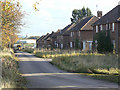
Former RAF Newton
The housing nearest to the Fosse Way has remained empty for a number of years and is becoming increasingly derelict.
Image: © Alan Murray-Rust
Taken: 23 Oct 2009
0.14 miles
9
Dereliction at RAF Newton
The area of housing nearest to the Fosse Way is becoming increasingly derelict.
Image: © Alan Murray-Rust
Taken: 23 Oct 2009
0.15 miles
10
Newton Gardens
Formerly lined with officers' housing for RAF Newton. The housing was allowed to deteriorate and was then demolished. Now serves as the entrance to a business park.
Image: © Jonathan Thacker
Taken: 4 Dec 2019
0.15 miles