IMAGES TAKEN NEAR TO
The Sands, NOTTINGHAM, NG13 0HP
Introduction
This page details the photographs taken nearby to The Sands, NG13 0HP by members of the Geograph project.
The Geograph project started in 2005 with the aim of publishing, organising and preserving representative images for every square kilometre of Great Britain, Ireland and the Isle of Man.

There are currently over 7.5m images from over14,400 individuals and you can help contribute to the project by visiting https://www.geograph.org.uk
Image Map
Images are licensed for reuse under creativecommons.org/licenses/by-sa/2.0
Notes
- Clicking on the map will re-center to the selected point.
- The higher the marker number, the further away the image location is from the centre of the postcode.
Image Listing (11 Images Found)
Images are licensed for reuse under creativecommons.org/licenses/by-sa/2.0
Image
Details
Distance
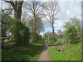
1

Autumn along Belvoir Road
In the Leicestershire village of Bottesford.
Image: © Mat Fascione
Taken: 12 Oct 2008
0.09 miles
2

The village of Bottesford, Leicestershire
At 212 feet, the spire of St. Mary's Church is the highest in Leicestershire.
Image: © Mat Fascione
Taken: 12 Oct 2008
0.10 miles
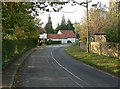
5

Winterbeck Bridge
It carries Belvoir Road across Winter Beck, on the southern edge of Bottesford.
Image: © Mat Fascione
Taken: 12 Oct 2008
0.20 miles
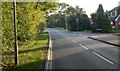
6

Belvoir Road crossing Winterbeck Bridge
On the southern edge of the Leicestershire village of Bottesford.
Image: © Mat Fascione
Taken: 12 Oct 2008
0.20 miles
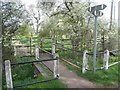
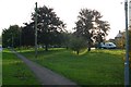
8
Footpath at Bottesford
Links Easthorpe with the centre of the village.
Image: © Jonathan Thacker
Taken: 10 Apr 2012
0.23 miles