IMAGES TAKEN NEAR TO
Woolsthorpe Lane, NOTTINGHAM, NG13 0GW
Introduction
This page details the photographs taken nearby to Woolsthorpe Lane, NG13 0GW by members of the Geograph project.
The Geograph project started in 2005 with the aim of publishing, organising and preserving representative images for every square kilometre of Great Britain, Ireland and the Isle of Man.

There are currently over 7.5m images from over14,400 individuals and you can help contribute to the project by visiting https://www.geograph.org.uk
Image Map
Images are licensed for reuse under creativecommons.org/licenses/by-sa/2.0
Notes
- Clicking on the map will re-center to the selected point.
- The higher the marker number, the further away the image location is from the centre of the postcode.
Image Listing (5 Images Found)
Images are licensed for reuse under creativecommons.org/licenses/by-sa/2.0
Image
Details
Distance
1
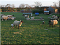
Lincolnshire Sheep.
The buildings behind are the old Mill Farm.
Image: © Kate Jewell
Taken: 16 Apr 2006
0.08 miles
2
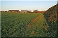
Mill Farm near Muston
Although near Muston this farm is just in Lincolnshire. The public footpath to Muston is just the other side of the hedge.
Image: © Kate Jewell
Taken: 16 Apr 2006
0.08 miles
3
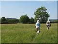
Muston special nature reserve
The Vale of Belvoir, pleasant walking with the Belvoir Castle ridge in the background.
Image: © Eric Foxley
Taken: 1 Jun 2007
0.11 miles
4
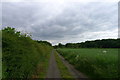
Track from Muston towards Sewstern Lane
Mill Farm at the end of the track
Image: © Tim Heaton
Taken: 5 Jun 2014
0.21 miles
5
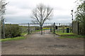
Gates at entrance to Sedgebrook Mill
On cycle route 15, Woolsthorpe Lane.
Image: © J.Hannan-Briggs
Taken: 6 Apr 2014
0.24 miles