IMAGES TAKEN NEAR TO
Main Road, NOTTINGHAM, NG13 0GQ
Introduction
This page details the photographs taken nearby to Main Road, NG13 0GQ by members of the Geograph project.
The Geograph project started in 2005 with the aim of publishing, organising and preserving representative images for every square kilometre of Great Britain, Ireland and the Isle of Man.

There are currently over 7.5m images from over14,400 individuals and you can help contribute to the project by visiting https://www.geograph.org.uk
Image Map
Images are licensed for reuse under creativecommons.org/licenses/by-sa/2.0
Notes
- Clicking on the map will re-center to the selected point.
- The higher the marker number, the further away the image location is from the centre of the postcode.
Image Listing (41 Images Found)
Images are licensed for reuse under creativecommons.org/licenses/by-sa/2.0
Image
Details
Distance
2

Roadway to former Redmile Station
The British Railways Board sign declaring this to be private property is a clue that there was once a station here. The station was a fair trek from the village and it is hardly surprising that it closed as long ago as 1953. Although now defunct, the British Railways Board continued to exist for some years after the network was privatised dealing with residual issues including the maintenance of structures on disused lines.
Image: © Stephen McKay
Taken: 17 May 2022
0.07 miles
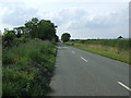
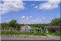
3

Road near Redmile
This road heads north-west from Redmile towards the A52 near Whatton. Ahead is the bridge over the long-disused Market Harborough to Newark railway.
Image: © Stephen McKay
Taken: 17 May 2022
0.10 miles
5
Old railway track, Vale of Belvoir
Taken from the bridge this is the line of the old railway that used to run between Melton Mowbray and Bottesford. Now a place of autumn feasting for wildlife.
Image: © Kate Jewell
Taken: 9 Oct 2005
0.12 miles
6
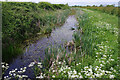
Grantham Canal, near Barkestone-le-Vale
The unnavigable canal is seen here close to bridge 53.
Image: © Stephen McKay
Taken: 17 May 2022
0.12 miles
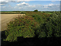
8
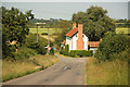
Peacock Farm
View from Redmile Mill Bridge to Peacock Farm http://www.peacock-farm.co.uk/
Image: © Richard Croft
Taken: 9 Jul 2013
0.13 miles
9
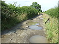
Barkestone Lane
A rough track at this point.
Image: © JThomas
Taken: 27 Jul 2013
0.13 miles
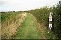
10

Track north of Peacock Farm
A man heads along this track which eventually leads to Bottesford. It is a public right of way.
Image: © Stephen McKay
Taken: 17 May 2022
0.13 miles