IMAGES TAKEN NEAR TO
Redmile, NOTTINGHAM, NG13 0GP
Introduction
This page details the photographs taken nearby to NG13 0GP by members of the Geograph project.
The Geograph project started in 2005 with the aim of publishing, organising and preserving representative images for every square kilometre of Great Britain, Ireland and the Isle of Man.

There are currently over 7.5m images from over14,400 individuals and you can help contribute to the project by visiting https://www.geograph.org.uk
Image Map
Images are licensed for reuse under creativecommons.org/licenses/by-sa/2.0
Notes
- Clicking on the map will re-center to the selected point.
- The higher the marker number, the further away the image location is from the centre of the postcode.
Image Listing (3 Images Found)
Images are licensed for reuse under creativecommons.org/licenses/by-sa/2.0
Image
Details
Distance
2
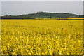
A circular walk from Redmile, (53)
Belvoir Castle seen across a sea of yellow from the footpath between Redmile and Muston Gorse.
To follow this walk of about 6 miles along the canal and public footpaths, park in the village of Redmile somewhere near the Peacock Inn and walk north west out of the village to the bridge where you can gain access to the tow path. Photographs taken along the length of the walk are collected here: http://www.geograph.org.uk/search.php?i=2770823
Image: © Kate Jewell
Taken: 5 May 2008
0.13 miles
3
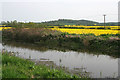
A circular walk from Redmile, (40)
From the Grantham Canal the rape fields stretch right up to Belvoir Castle. Pronounced "Beaver", the Castle is a clear land mark at this end of the Vale of Belvoir. Owned by the Duke of Rutland it occupies a commanding position at the end of the hills that bound the south eastern edge of the Vale.
To follow this walk of about 6 miles along the canal and public footpaths, park in the village of Redmile somewhere near the Peacock Inn and walk north west out of the village to the bridge where you can gain access to the tow path. Photographs taken along the length of the walk are collected here: http://www.geograph.org.uk/search.php?i=2770823
Image: © Kate Jewell
Taken: 5 May 2008
0.23 miles