IMAGES TAKEN NEAR TO
Church Lane, NOTTINGHAM, NG13 0GE
Introduction
This page details the photographs taken nearby to Church Lane, NG13 0GE by members of the Geograph project.
The Geograph project started in 2005 with the aim of publishing, organising and preserving representative images for every square kilometre of Great Britain, Ireland and the Isle of Man.

There are currently over 7.5m images from over14,400 individuals and you can help contribute to the project by visiting https://www.geograph.org.uk
Image Map
Images are licensed for reuse under creativecommons.org/licenses/by-sa/2.0
Notes
- Clicking on the map will re-center to the selected point.
- The higher the marker number, the further away the image location is from the centre of the postcode.
Image Listing (91 Images Found)
Images are licensed for reuse under creativecommons.org/licenses/by-sa/2.0
Image
Details
Distance
1
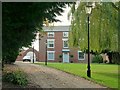
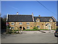
Redmile House
Late 18th century Georgian farmhouse, 2 ½ storeys and 3 bays, Listed grade II.
Image: © Alan Murray-Rust
Taken: 23 Oct 2016
0.05 miles
2
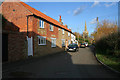
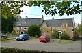
Church Lane, Redmile
Looking towards St Peter's Church.
There are several converted farm buildings along this lane which leads to a small development of 1970 to 80s bungalows and houses.
(Taken on the 1,000th day of geograph.org.uk)
Image: © Kate Jewell
Taken: 1 Dec 2007
0.05 miles
3
A Vale of Belvoir Peacock, Redmile, Leicestershire
A brick and stone Vale of Belvoir village with some very interesting vernacular architecture, including the Peacock Inn! More info at http://www.granthamcanal.com/leisure/peacock.htm
Image: © Kate Jewell
Taken: 9 Oct 2005
0.08 miles
4
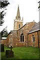
St.Peter's church
Ironstone restored 13th & 14th century church
Image: © Richard Croft
Taken: 28 Aug 2008
0.09 miles
5
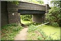
Redmile Bridge
Otherwise known as bridge 54 at Redmile over the disused Grantham Canal
Image: © Richard Croft
Taken: 28 Aug 2008
0.09 miles
6
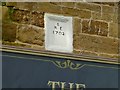
Datestone, Peacock Inn, Redmile
See http://www.geograph.org.uk/photo/5170093 for location.
Image: © Alan Murray-Rust
Taken: 23 Oct 2016
0.09 miles
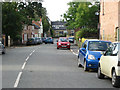
7
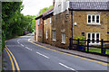
Main Street, Redmile
Redmile is a small Vale of Belvoir village; its population in 2011 was recorded as 921 but this was for the whole civil parish including Plungar and Barkestone-le-Vale. This view is at the west end of the village from Church Corner approaching the canal bridge. The building on the right was formerly the Peacock Inn, now converted into four cottages despite an attempt to have it designated an asset of community value. Fortunately, the village does have another pub. See Image for a view of the Peacock in happier times.
Image: © Stephen McKay
Taken: 17 May 2022
0.10 miles
8
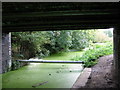
Redmile Town Bridge, No 54, Grantham Canal, Redmile
Nearly every available open stretch of water along the canal has a dense covering of duck weed this year. Drainage pipe at ground level across the canal. Limbo dancing for bargees I think!
Image: © Kate Jewell
Taken: 9 Oct 2005
0.10 miles
9
The former Peacock Inn, Redmile
Dates from 1702 https://historicengland.org.uk/listing/the-list/list-entry/1294657 Now named Dove Cottage.
Image: © Jonathan Thacker
Taken: 30 Mar 2019
0.10 miles
10
Peacock Inn, Redmile
Closed and unoccupied at the time of my visit. The left hand part of the building is dated 1702 and is Listed grade II. The black glazed pantiles seem to be quite local to the area.
Image: © Alan Murray-Rust
Taken: 23 Oct 2016
0.10 miles