IMAGES TAKEN NEAR TO
Hoopers Close, NOTTINGHAM, NG13 0FH
Introduction
This page details the photographs taken nearby to Hoopers Close, NG13 0FH by members of the Geograph project.
The Geograph project started in 2005 with the aim of publishing, organising and preserving representative images for every square kilometre of Great Britain, Ireland and the Isle of Man.

There are currently over 7.5m images from over14,400 individuals and you can help contribute to the project by visiting https://www.geograph.org.uk
Image Map
Images are licensed for reuse under creativecommons.org/licenses/by-sa/2.0
Notes
- Clicking on the map will re-center to the selected point.
- The higher the marker number, the further away the image location is from the centre of the postcode.
Image Listing (52 Images Found)
Images are licensed for reuse under creativecommons.org/licenses/by-sa/2.0
Image
Details
Distance
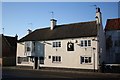
1
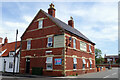
The Rutland Arms, Bottesford
This pub on High Street takes its name from the occupants of nearby Belvoir Castle. It incorporates an Indian restaurant.
Image: © Stephen McKay
Taken: 17 May 2022
0.12 miles
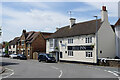
2
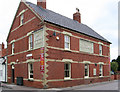
Bottesford - The Rutland Arms
On High Street.
Image: © Dave Bevis
Taken: 15 Jun 2011
0.12 miles
3
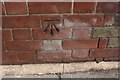
Benchmark on the Rutland Arms
Ordnance Survey cut mark benchmark described on the Bench Mark Database at www.bench-marks.org.uk/bm69106
Image: © Roger Templeman
Taken: 7 May 2019
0.13 miles
4
the Rutland Arms, High Street
There is an OS benchmark Image on the near corner, road face, of the pub.
Image: © Roger Templeman
Taken: 7 May 2019
0.13 miles
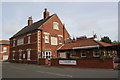
7

Market Street in Bottesford
At 212 feet, the spire of St. Mary's Church is the highest in Leicestershire.
Image: © Mat Fascione
Taken: 12 Oct 2008
0.15 miles
8
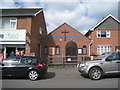
Bottesford Baptist church
On Queen Street.
Image: © Jonathan Thacker
Taken: 10 Apr 2012
0.15 miles
9
The Bull Inn
Historic inn on Market Street dating from 1726 on the site of an earlier inn. Stan Laurel's sister Olga and her husband Bill were once the landlord & landlady, a commemorative plaque reads ...
"Stan Laurel and Oliver Hardy stayed at this 18th Century Inn whilst appearing at the Empire Theatre Nottingham during Christmas 1952"
http://www.bottesfordhistory.org.uk/page_id__124.aspx
Image: © Richard Croft
Taken: 13 Dec 2007
0.15 miles
10
The Bull Inn, Bottesford
The Bull Inn on Market Street has a claim to fame. In the 1950s it was run by Olga Healy, the sister of Stan Laurel; Stan and Oliver Hardy stayed here while performing in Nottingham. The pub is full of Laurel and Hardy memorabilia.
The road here was part of the A52 between Nottingham and Grantam until Bottesford was by-passed in 1989. Apart from this old turnpike road, Bottesford is on the Nottingham - Grantham railway and the disused Grantham Canal, which also connected the two towns, passes nearby. All this reinforces the impression that Bottesford is in the wrong county; its natural traffic flows connect to places in Nottinghamshire and Lincolnshire. It is of course in Leicestershire but feels a very long way from, for example, Lutterworth.
Image: © Stephen McKay
Taken: 17 May 2022
0.17 miles