IMAGES TAKEN NEAR TO
Main Street, NOTTINGHAM, NG13 0FB
Introduction
This page details the photographs taken nearby to Main Street, NG13 0FB by members of the Geograph project.
The Geograph project started in 2005 with the aim of publishing, organising and preserving representative images for every square kilometre of Great Britain, Ireland and the Isle of Man.

There are currently over 7.5m images from over14,400 individuals and you can help contribute to the project by visiting https://www.geograph.org.uk
Image Map
Images are licensed for reuse under creativecommons.org/licenses/by-sa/2.0
Notes
- Clicking on the map will re-center to the selected point.
- The higher the marker number, the further away the image location is from the centre of the postcode.
Image Listing (65 Images Found)
Images are licensed for reuse under creativecommons.org/licenses/by-sa/2.0
Image
Details
Distance
1
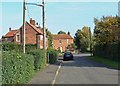
Muston: Main Street
A small village in the Vale of Belvoir, north-east Leicestershire.
Image: © Mat Fascione
Taken: 12 Oct 2008
0.03 miles
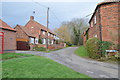
2
Main Street, Muston
Typically unexceptional.
Image: © Alan Murray-Rust
Taken: 9 Feb 2017
0.04 miles
3
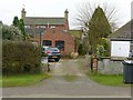
Manor House, Muston
The owners of this house have to live with the presence of a public footpath through their property. How much this is actually used is another matter, as it only cuts off quite a short corner.
Image: © Alan Murray-Rust
Taken: 9 Feb 2017
0.04 miles
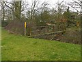
4
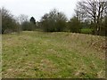
Medieval moated grange, Muston
This was a monastic grange, or farm, belong to Olveston Priory, near Bristol. This is part of the northern leg of the moat, which would have been up to 15 metres wide and 2 metres deep. It follows the curve of the River Devon on this side. The site is a Scheduled Monument.
Image: © Alan Murray-Rust
Taken: 9 Feb 2017
0.07 miles
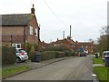
6
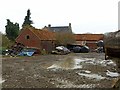
Farmyard at Hospital Farm
Traditional farmyard, clearly still very much in use.
Image: © Alan Murray-Rust
Taken: 9 Feb 2017
0.10 miles
7
Footbridge, Muston
Consisting of a simple concrete beam with single handrail. Crossing the River Devon.
Image: © Alan Murray-Rust
Taken: 9 Feb 2017
0.11 miles
8
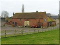
Barn at Hospital Farm, Muston
A nice example of a brick threshing barn of the period, dated 1807 in black bricks. Unconverted, the farm still being in operation.
Image: © Alan Murray-Rust
Taken: 9 Feb 2017
0.11 miles
9
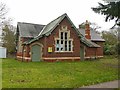
The Old School, Muston
Now used as the village hall.
Image: © Alan Murray-Rust
Taken: 9 Feb 2017
0.11 miles
10
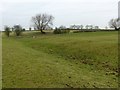
Medieval moated grange, Muston
This was a monastic grange, or farm, belonging to Olveston Priory, near Bristol. Here is part of the eastern leg of the moat, which would have been up to 15 metres wide and 2 metres deep. The site is a Scheduled Monument.
Image: © Alan Murray-Rust
Taken: 9 Feb 2017
0.12 miles