IMAGES TAKEN NEAR TO
Main Street, NOTTINGHAM, NG13 0EP
Introduction
This page details the photographs taken nearby to Main Street, NG13 0EP by members of the Geograph project.
The Geograph project started in 2005 with the aim of publishing, organising and preserving representative images for every square kilometre of Great Britain, Ireland and the Isle of Man.

There are currently over 7.5m images from over14,400 individuals and you can help contribute to the project by visiting https://www.geograph.org.uk
Image Map
Images are licensed for reuse under creativecommons.org/licenses/by-sa/2.0
Notes
- Clicking on the map will re-center to the selected point.
- The higher the marker number, the further away the image location is from the centre of the postcode.
Image Listing (12 Images Found)
Images are licensed for reuse under creativecommons.org/licenses/by-sa/2.0
Image
Details
Distance
1
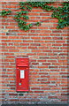
George V Postbox
Mounted within a house wall in Normanton.
Image: © David Lally
Taken: 24 Aug 2008
0.03 miles
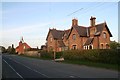
2
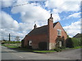
Cottage in Normanton
Not unattractive but a bit of a hotch-potch with its mixture of building materials -ironstone and brick from at least three different periods.
Image: © Jonathan Thacker
Taken: 10 Apr 2012
0.16 miles
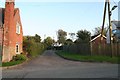
4
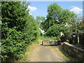
End of the lane, Normanton
From here on the bridleway runs through fields.
Image: © Jonathan Thacker
Taken: 27 May 2020
0.17 miles
5
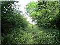
Rather overgrown bridleway, Normanton
Overgrown but still passable.
Image: © Jonathan Thacker
Taken: 27 May 2020
0.17 miles
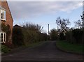
8
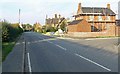
Leicestershire's northernmost village
Looking north along Normanton Lane in the village of Normanton.
Image: © Mat Fascione
Taken: 12 Oct 2008
0.19 miles
10
Bridleway and straw stack
The bridleway goes straight ahead.
Image: © Jonathan Thacker
Taken: 27 May 2020
0.21 miles