IMAGES TAKEN NEAR TO
Rutland Lane, NOTTINGHAM, NG13 0DG
Introduction
This page details the photographs taken nearby to Rutland Lane, NG13 0DG by members of the Geograph project.
The Geograph project started in 2005 with the aim of publishing, organising and preserving representative images for every square kilometre of Great Britain, Ireland and the Isle of Man.

There are currently over 7.5m images from over14,400 individuals and you can help contribute to the project by visiting https://www.geograph.org.uk
Image Map
Images are licensed for reuse under creativecommons.org/licenses/by-sa/2.0
Notes
- Clicking on the map will re-center to the selected point.
- The higher the marker number, the further away the image location is from the centre of the postcode.
Image Listing (242 Images Found)
Images are licensed for reuse under creativecommons.org/licenses/by-sa/2.0
Image
Details
Distance
1
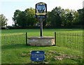
Bottesford village sign and commemorative railings
Located on a green along Grantham Road.
Image: © Mat Fascione
Taken: 12 Oct 2008
0.04 miles
2
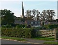
The village of Bottesford in Leicestershire
At 212 feet, the spire of St. Mary's Church is the highest in Leicestershire.
Image: © Mat Fascione
Taken: 12 Oct 2008
0.06 miles
3
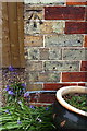
Benchmark on #11 Easthorpe Road
Ordnance Survey cut mark benchmark described on the Bench Mark Database at www.bench-marks.org.uk/bm108657
Image: © Roger Templeman
Taken: 7 May 2019
0.06 miles
4
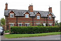
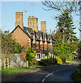
#11 ('Tall Chimneys') and #13 Easthorpe Road
There is an OS benchmark Image on the front of the left hand house at its left hand corner (at junction with wooden gate)
Image: © Roger Templeman
Taken: 7 May 2019
0.06 miles
5
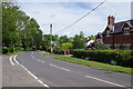
Easthorpe Road, Bottesford
Rutland Lane leads off to the left; ahead Easthorpe Road joins Grantham Road on the eastern edge of Bottesford.
Image: © Stephen McKay
Taken: 17 May 2022
0.06 miles
6
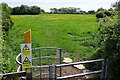
Footpath to Easthorpe
The footpath heads across fields from Easthorpe Road cutting off a corner towards Easthorpe village. It does not look very well used and walkers are warned that there are cows with calves here (although none are visible in this view).
Image: © Stephen McKay
Taken: 17 May 2022
0.10 miles
7
Easthorpe Road
Entering Bottesford from Easthorpe
Image: © Richard Croft
Taken: 28 May 2012
0.11 miles
8
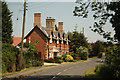
Impressive chimneys on Easthorpe Road
Easthorpe Road in Bottesfield. According to large scale mapping there are just two houses in the row when there might have been thought to be four.
Image: © Trevor Littlewood
Taken: 9 Nov 2022
0.11 miles
9
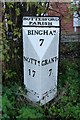
Old Milepost by the former A52, Grantham Road, Bottesford
Cast iron post by the UC road (was A52), in parish of BOTTESFORD (MELTON District), Grantham Road, opposite Wyggeston Road, on the verge, on South side of road. Boothby iron casting, erected by the Grantham & Nottingham, E division turnpike trust in the 19th century.
Inscription reads:- : NOTTM. / 17 : : BOTTESFORD / PARISH / BINGHAM / 7 : : GRANTM. / 7 : : BOOTHBY & CO / NOTTINGHAM :
Milestone Society National ID: LE_NTGT17.
Image: © J Higgins
Taken: 1 Nov 2004
0.12 miles
10
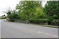
Washdyke Bridge taking Grantham Road over stream
Image: © Roger Templeman
Taken: 7 May 2019
0.12 miles