IMAGES TAKEN NEAR TO
Orston Lane, NOTTINGHAM, NG13 0AU
Introduction
This page details the photographs taken nearby to Orston Lane, NG13 0AU by members of the Geograph project.
The Geograph project started in 2005 with the aim of publishing, organising and preserving representative images for every square kilometre of Great Britain, Ireland and the Isle of Man.

There are currently over 7.5m images from over14,400 individuals and you can help contribute to the project by visiting https://www.geograph.org.uk
Image Map
Images are licensed for reuse under creativecommons.org/licenses/by-sa/2.0
Notes
- Clicking on the map will re-center to the selected point.
- The higher the marker number, the further away the image location is from the centre of the postcode.
Image Listing (11 Images Found)
Images are licensed for reuse under creativecommons.org/licenses/by-sa/2.0
Image
Details
Distance
1

Lane along the old railway line
This is the trackbed of the former Great Northern and London and North Western Railways' joint line between Market Harborough and Newark. It provides private trackside access to the Nottingham - Grantham line which is still in use.
Image: © Alan Murray-Rust
Taken: 6 Apr 2014
0.04 miles
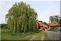
2

Orston Lane near Bottesford
Across the flat Vale of Belvoir countryside.
Image: © Mat Fascione
Taken: 12 Oct 2008
0.07 miles
3

The site of Bottesford South Junction
This was at one time a three-way junction on the former Great Northern and London and North Western Railways' joint line between Market Harborough and Newark. Straight ahead was the direct line to Newark (actually owned entirely by the Great Northern Railway).
The curves to left and right gave access towards Nottingham and Grantham respectively. The principal traffics were ironstone from the local Leicestershire Wolds and coal from Nottinghamshire towards London, although most of the latter used the later connecting line from Bingham to Stathern. As a result the original left hand curve was removed, but was reinstated for oil traffic to the Redmile oil depot created to serve local airfields during the Second World War. The surfaced track is lineside access for railway staff.
Image: © Alan Murray-Rust
Taken: 6 Apr 2014
0.09 miles
4

Bowbridge Lane, Bottesford
A modern (1980s) housing estate. Most of the modern development in this large village is to the west.
Image: © Kate Jewell
Taken: 11 Oct 2005
0.10 miles

6

Direction Sign - Signpost by Nottingham Road, Bottesford parish
Ball finial - 3 arms; Leics. simple ball by the UC road, in parish of Bottesford (Melton District), junction of Nottingham Road with Longhedge Lane, on verge.
Surveyed
Milestone Society National ID: LE_SK7938
Image: © Milestone Society
Taken: Unknown
0.19 miles
7
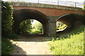
Nottingham Road bridge
Route of the Great Northern Railway and London & North Western Railway joint railway near Bottesford http://www.meltonmowbray.steamrailways.com/Bott-Redmile.htm opened 1879, closed 1964
Image: © Richard Croft
Taken: 28 May 2012
0.19 miles
8

Former trackbed
Curve to Bottesford West Junction on a disused trackbed, now surfaced as an access road
Image: © Richard Croft
Taken: 28 May 2012
0.20 miles
10

Site of Bottesford South Station
Route of the Great Northern Railway and London & North Western Railway joint railway at the site of Bottesford South Station http://www.meltonmowbray.steamrailways.com/Bott-Redmile.htm opened 1879, closed 1964
Image: © Richard Croft
Taken: 28 May 2012
0.24 miles