IMAGES TAKEN NEAR TO
Wilson Avenue, NG12 5SY
Introduction
This page details the photographs taken nearby to Wilson Avenue, NG12 5SY by members of the Geograph project.
The Geograph project started in 2005 with the aim of publishing, organising and preserving representative images for every square kilometre of Great Britain, Ireland and the Isle of Man.

There are currently over 7.5m images from over14,400 individuals and you can help contribute to the project by visiting https://www.geograph.org.uk
Image Map
Images are licensed for reuse under creativecommons.org/licenses/by-sa/2.0
Notes
- Clicking on the map will re-center to the selected point.
- The higher the marker number, the further away the image location is from the centre of the postcode.
Image Listing (15 Images Found)
Images are licensed for reuse under creativecommons.org/licenses/by-sa/2.0
Image
Details
Distance
1

New housing at Nicker Hill
A large development of some 150 homes.
Image: © Alan Murray-Rust
Taken: 17 Jan 2022
0.08 miles
2
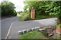
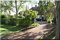
Entrance to Barnfield Farm from Nicker Hill
The culvert in the right foreground once had an Ordnance Survey benchmark on its top, but this appears to have been lost as the top stones have been lost.
Image: © Roger Templeman
Taken: 14 Sep 2018
0.18 miles
3
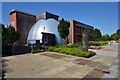
William Smith Building - British Geological Survey
Full of geologists and geoscientists, my desk is on the top floor although I'm mostly in the labs.
Image: © Ashley Dace
Taken: 24 Jul 2014
0.19 miles
4

British Geological Survey, Keyworth
Recreating this 'First' for the square https://www.geograph.org.uk/photo/88573 as best as can be done. The original was taken from a location which is either not publicly accessible, or where a hedge has grown to a height which means that no photo is available.
Image: © Alan Murray-Rust
Taken: 17 Jan 2022
0.19 miles
5
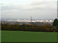
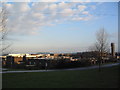
Sunlight on Nottingham
View from the bridleway between the top of Nicker Hill and Normanton.
Image: © Alan Murray-Rust
Taken: 1 Nov 2011
0.19 miles
6
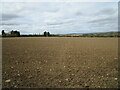
Footpath across a prepared field
The route of the path is just about discernable.
Image: © Jonathan Thacker
Taken: 8 Apr 2021
0.19 miles
7
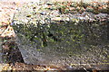
Benchmark on low wall at entrance to #100 Nicker Hill
Ordnance Survey rivet benchmark levelled at 87.084m above Newlyn Datum
Image: © Roger Templeman
Taken: 14 Sep 2018
0.20 miles
8
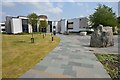
British Geological Survey, Keyworth
Founded in 1835, the world's longest established national geological survey, and the UK's premier centre for earth science information and expertise. http://www.bgs.ac.uk/. The Survey headquarters moved to Keyworth in 1976.
Image: © Tim Heaton
Taken: 8 Dec 2005
0.21 miles
9
#100 Nicker Hill
There is an OS benchmark Image on the near end of the right hand low wall at the entrance drive to the house
Image: © Roger Templeman
Taken: 14 Sep 2018
0.21 miles
10
British Geological Survey
Start of the rock walk and the gift shop.
Image: © Ashley Dace
Taken: 1 Aug 2014
0.23 miles