IMAGES TAKEN NEAR TO
Derrick Close, NOTTINGHAM, NG12 5SH
Introduction
This page details the photographs taken nearby to Derrick Close, NG12 5SH by members of the Geograph project.
The Geograph project started in 2005 with the aim of publishing, organising and preserving representative images for every square kilometre of Great Britain, Ireland and the Isle of Man.

There are currently over 7.5m images from over14,400 individuals and you can help contribute to the project by visiting https://www.geograph.org.uk
Image Map
Images are licensed for reuse under creativecommons.org/licenses/by-sa/2.0
Notes
- Clicking on the map will re-center to the selected point.
- The higher the marker number, the further away the image location is from the centre of the postcode.
Image Listing (25 Images Found)
Images are licensed for reuse under creativecommons.org/licenses/by-sa/2.0
Image
Details
Distance
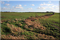
1

Fields to the west of Keyworth
There appears to be some trace of ridge and furrow cultivation. Not an exciting picture, but it shows what is there!
Image: © Alan Murray-Rust
Taken: 1 Nov 2011
0.09 miles
2
Farmland from Blackcliffe Hill
Looking across the featured square towards Keyworth and Plumtree Park from Plumtree Lane. Cotton's Plantation is on the right horizon and the houses at Keyworth can just be made out on the centre horizon.
Image: © Kate Jewell
Taken: 24 Jan 2008
0.11 miles
3

Intake Road
The word intake typically refers to land enclosed from moorland or common land, but there appears to be no historic evidence for its use at this location.
Image: © Alan Murray-Rust
Taken: 1 Nov 2011
0.14 miles
4
Debdale Lane, Keyworth
Track leading into Keyworth from the west. Pumping station on right
Image: © Tim Heaton
Taken: 8 Sep 2006
0.14 miles
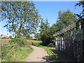
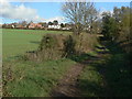
5
The end of Debdale Lane
The lane peters out straight into this field. In practice it also marks the parish boundary between Keyworth and Bunny, which also follows the hedge to the left.
Image: © Alan Murray-Rust
Taken: 1 Nov 2011
0.15 miles
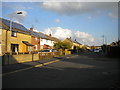
7

Park Avenue West
Local authority development from the 1960s, intended in part for miners at the neighbouring Cotgrave Colliery.
Image: © Alan Murray-Rust
Taken: 1 Nov 2011
0.17 miles
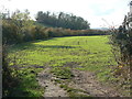
9
The end of Debdale Lane
Looking back towards Keyworth. It's not clear whether this is still a public road at this point, although large scale OS maps suggest that it is, regardless of the surface.
Image: © Alan Murray-Rust
Taken: 1 Nov 2011
0.19 miles
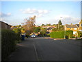
10

Gorse Road
The houses to the left are a much more recent addition to those on the right hand side, developed in the 1960s. At the time the picture was taken, they were not shown on the 1:25000 map.
Image: © Alan Murray-Rust
Taken: 1 Nov 2011
0.19 miles