IMAGES TAKEN NEAR TO
Wrights Orchard, NOTTINGHAM, NG12 5RE
Introduction
This page details the photographs taken nearby to Wrights Orchard, NG12 5RE by members of the Geograph project.
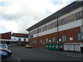
The Geograph project started in 2005 with the aim of publishing, organising and preserving representative images for every square kilometre of Great Britain, Ireland and the Isle of Man.

There are currently over 7.5m images from over14,400 individuals and you can help contribute to the project by visiting https://www.geograph.org.uk
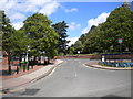
Image Map
Images are licensed for reuse under creativecommons.org/licenses/by-sa/2.0
Notes
- Clicking on the map will re-center to the selected point.
- The higher the marker number, the further away the image location is from the centre of the postcode.
Image Listing (105 Images Found)
Images are licensed for reuse under creativecommons.org/licenses/by-sa/2.0
Image
Details
Distance
1
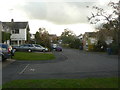
Wright's Orchard
Part of the 1970s/80s development in the south-western sector of the village.
Image: © Alan Murray-Rust
Taken: 1 Nov 2011
0.02 miles
2
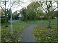
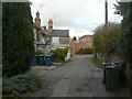
Estate footpath
The south-western corner of the village was developed in the 1970s/80s the modern idiom with pedestrian access separated as much as possible from vehicles. This path also maintains a traditional right of way which extends to the neighbouring village of Bunny.
Image: © Alan Murray-Rust
Taken: 1 Nov 2011
0.03 miles
3
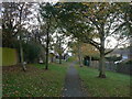
Estate footpath
The south-western corner of the village was developed in the modern idiom with pedestrian access separated as much as possible from vehicles. This path runs between Wright's Orchard and Brook View Drive.
Image: © Alan Murray-Rust
Taken: 1 Nov 2011
0.04 miles
4
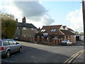
Keyworth Police Station
A modern building just off Keyworth Square.
Image: © Alan Murray-Rust
Taken: 1 Nov 2011
0.06 miles
5
Keyworth NHS Primary Care Centre
A large NHS facility opened in 2007, with a General Medical Practice on the first floor and Community Staff (nurses, midwives, health visitors etc.) on the ground floor.
Image: © Alan Murray-Rust
Taken: 1 Nov 2011
0.06 miles
6
Blind Lane
The name sign for this road reads 'Blind Lane, formerly Commercial Road'. In practice the name has reverted to the original name, which appears on older maps. It is one of the older streets of the village. Commercial Road is the road which passes at the end of the lane.
Image: © Alan Murray-Rust
Taken: 1 Nov 2011
0.07 miles
7
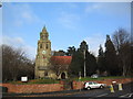
Church of St Mary Magdalene, Keyworth
http://southwellchurches.nottingham.ac.uk/keyworth/hintro.php
Image: © Tim Heaton
Taken: 8 Dec 2005
0.07 miles
8
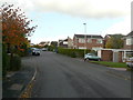
Brook View Drive
This is the main road through the 1970s development in the south-western sector of Keyworth.
Image: © Alan Murray-Rust
Taken: 1 Nov 2011
0.08 miles
9

Shops on The Square behind an old signpost
Image: © Roger Templeman
Taken: 14 Sep 2018
0.08 miles
10
Bus stop in Keyworth Square
Being situated in the Square, this bus stop can be accessed by buses travelling to or from any direction.
Image: © Richard Vince
Taken: 6 Jun 2015
0.09 miles