IMAGES TAKEN NEAR TO
Rempstone Lane, NOTTINGHAM, NG12 5QZ
Introduction
This page details the photographs taken nearby to Rempstone Lane, NG12 5QZ by members of the Geograph project.
The Geograph project started in 2005 with the aim of publishing, organising and preserving representative images for every square kilometre of Great Britain, Ireland and the Isle of Man.

There are currently over 7.5m images from over14,400 individuals and you can help contribute to the project by visiting https://www.geograph.org.uk
Image Map
Images are licensed for reuse under creativecommons.org/licenses/by-sa/2.0
Notes
- Clicking on the map will re-center to the selected point.
- The higher the marker number, the further away the image location is from the centre of the postcode.
Image Listing (15 Images Found)
Images are licensed for reuse under creativecommons.org/licenses/by-sa/2.0
Image
Details
Distance
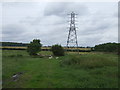
2
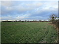
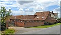
Grass field near Scotland Hill Farm
Image: © Jonathan Thacker
Taken: 29 Dec 2022
0.08 miles
3
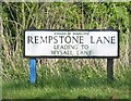
Sign on Rempstone Lane at the junction with Wysall Road
This road is clearly marked. Most maps names the road as Wysall Road but this sign could not be clearer! Wysall Lane was found on one street map but no sign of Rempstone Lane and the point where the name changes.
Image: © Andrew Tatlow
Taken: 8 May 2009
0.12 miles
4
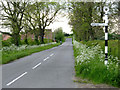
Fingerpost, Wysall Road
Notts C C modern cast-aluminium 'traditional' post with small annulus finial. Both the road ahead and the one to the left are called Wysall Road, former belonging to Costock, and the latter to Rempstone.
Image: © Alan Murray-Rust
Taken: 15 May 2014
0.12 miles
5
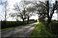
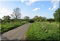
Rempstone Road westwards past Scotland Hill Farm
Image: © Andrew Tatlow
Taken: 8 May 2009
0.14 miles
8
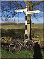
Direction Sign ? Signpost
Located on the north side of the T junction of Costock Road and Wysall Road in Wysall parish. 3 arms and annulus finial. See also http://www.geograph.org.uk/photo/3989277.
Milestone Society National ID: NT_SK5926
Image: © S Kenworthy
Taken: 27 Mar 2020
0.15 miles
10
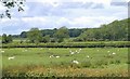
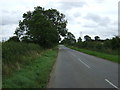
Sheep and Woods in Costock
Taken looking NNW opposite Scotland Hill Farm. Long Rough Plantation on the right, Intake Wood in the distance.
Image: © Chris J Dixon
Taken: 4 Jun 2005
0.16 miles