IMAGES TAKEN NEAR TO
Penn Lane, NOTTINGHAM, NG12 5QF
Introduction
This page details the photographs taken nearby to Penn Lane, NG12 5QF by members of the Geograph project.
The Geograph project started in 2005 with the aim of publishing, organising and preserving representative images for every square kilometre of Great Britain, Ireland and the Isle of Man.

There are currently over 7.5m images from over14,400 individuals and you can help contribute to the project by visiting https://www.geograph.org.uk
Image Map
Images are licensed for reuse under creativecommons.org/licenses/by-sa/2.0
Notes
- Clicking on the map will re-center to the selected point.
- The higher the marker number, the further away the image location is from the centre of the postcode.
Image Listing (10 Images Found)
Images are licensed for reuse under creativecommons.org/licenses/by-sa/2.0
Image
Details
Distance

5
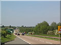
A46 Fosse Way
The busy A46, part of the Roman Fosse Way between Exeter and Lincoln, looking north to the junction with the A606 to Nottingham
Image: © Tim Heaton
Taken: 2 Jun 2006
0.19 miles
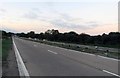

8
A46 heading south
On Fosse Way old Roman Road.
Image: © J.Hannan-Briggs
Taken: 3 Feb 2013
0.22 miles
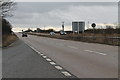
9

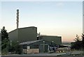
Signs at Waring Waste disposal site on A46
Image: © Andrew Tatlow
Taken: 2 Sep 2018
0.23 miles