IMAGES TAKEN NEAR TO
Widmerpool Lane, NOTTINGHAM, NG12 5QE
Introduction
This page details the photographs taken nearby to Widmerpool Lane, NG12 5QE by members of the Geograph project.
The Geograph project started in 2005 with the aim of publishing, organising and preserving representative images for every square kilometre of Great Britain, Ireland and the Isle of Man.

There are currently over 7.5m images from over14,400 individuals and you can help contribute to the project by visiting https://www.geograph.org.uk
Image Map
Images are licensed for reuse under creativecommons.org/licenses/by-sa/2.0
Notes
- Clicking on the map will re-center to the selected point.
- The higher the marker number, the further away the image location is from the centre of the postcode.
Image Listing (9 Images Found)
Images are licensed for reuse under creativecommons.org/licenses/by-sa/2.0
Image
Details
Distance
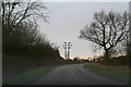
3
View from Wolds Lane
Looking towards North Lodge. This is the typical countryside of the area.
Image: © Alan Murray-Rust
Taken: 1 Nov 2011
0.16 miles
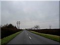
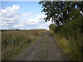
4
Keyworth bridleway BW7
This is the Widmerpool Lane end. It becomes Wolds Lane in due course.
Image: © Alan Murray-Rust
Taken: 1 Nov 2011
0.18 miles
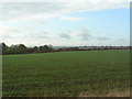
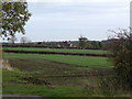
5

Crop field south of Keyworth
West of Widmerpool Lane.
Image: © JThomas
Taken: 21 Jun 2014
0.18 miles
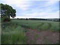

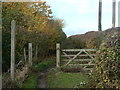
8
Track north of North Lodge Farm
Also host to a public footpath.
Image: © Richard Vince
Taken: 25 Aug 2018
0.24 miles
9
Farmland on Widmerpool Lane
The buildings beyond are Charlswold Court.
Image: © Alan Murray-Rust
Taken: 1 Nov 2011
0.24 miles