IMAGES TAKEN NEAR TO
Wolds Lane, NOTTINGHAM, NG12 5PB
Introduction
This page details the photographs taken nearby to Wolds Lane, NG12 5PB by members of the Geograph project.
The Geograph project started in 2005 with the aim of publishing, organising and preserving representative images for every square kilometre of Great Britain, Ireland and the Isle of Man.

There are currently over 7.5m images from over14,400 individuals and you can help contribute to the project by visiting https://www.geograph.org.uk
Image Map
Images are licensed for reuse under creativecommons.org/licenses/by-sa/2.0
Notes
- Clicking on the map will re-center to the selected point.
- The higher the marker number, the further away the image location is from the centre of the postcode.
Image Listing (34 Images Found)
Images are licensed for reuse under creativecommons.org/licenses/by-sa/2.0
Image
Details
Distance
1

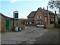
Harker's Farm Shop, Clipston
At Blackberry Farm. Not open on a Monday, when I was passing.
Image: © Alan Murray-Rust
Taken: 17 Jan 2022
0.02 miles
2
Blackberry Farm
An extensive farmhouse, from a variety of periods. Blackberry Farm is one of four that make up the hamlet of Clipston, all four still appearing to have a greater or lesser amount of farming activity.
Image: © Alan Murray-Rust
Taken: 20 Oct 2011
0.02 miles
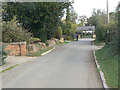
3

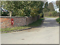
The Hamlet of "Clipston on the Wolds"
Recreating this 'First' for the square https://www.geograph.org.uk/photo/51973 .
The 30 mph speed limit was introduced around 2010. The lane forms part of the Notts Wolds Way long distance path.
Image: © Alan Murray-Rust
Taken: 17 Jan 2022
0.03 miles
4
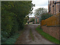
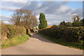
Top of Wolds Lane
The entry into the hamlet of Clipston, with Blackberry Farm on the right.
Image: © Alan Murray-Rust
Taken: 20 Oct 2011
0.04 miles
5
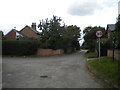
South end of Gilliver Lane, Clipston
Seen from the north end of Wolds Lane, with Church Lane on the left.
Image: © Richard Vince
Taken: 13 Aug 2016
0.04 miles
6
Church Gate, Clipston
The implication is that at one time Clipston had its own church, but it had certainly disappeared by the late 19th century. The name of the lane predates the erection of a tin tabernacle chapel of ease at the beginning of the 20th century, itself demolished in the 1940s.
Image: © Alan Murray-Rust
Taken: 20 Oct 2011
0.04 miles
7
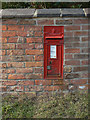
Clipston postbox ref no.NG12 127
A close up view of the box http://www.geograph.org.uk/photo/2667667. This one has had the original narrow posting slot replaced by the standard wide-slot modification.
Image: © Alan Murray-Rust
Taken: 20 Oct 2011
0.05 miles
8
Clipston postbox ref no.NG12 127
VR wall box situated at the junction of Church Gate and Gilliver Lane.
Image: © Alan Murray-Rust
Taken: 20 Oct 2011
0.05 miles
10
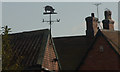
Clipston on the Wolds
Weather Vane on Harkers Farm roof
Image: © GLENN MANSFIELD
Taken: 12 Nov 2008
0.06 miles