IMAGES TAKEN NEAR TO
Clipston Lane, NOTTINGHAM, NG12 5NW
Introduction
This page details the photographs taken nearby to Clipston Lane, NG12 5NW by members of the Geograph project.
The Geograph project started in 2005 with the aim of publishing, organising and preserving representative images for every square kilometre of Great Britain, Ireland and the Isle of Man.

There are currently over 7.5m images from over14,400 individuals and you can help contribute to the project by visiting https://www.geograph.org.uk
Image Map
Images are licensed for reuse under creativecommons.org/licenses/by-sa/2.0
Notes
- Clicking on the map will re-center to the selected point.
- The higher the marker number, the further away the image location is from the centre of the postcode.
Image Listing (47 Images Found)
Images are licensed for reuse under creativecommons.org/licenses/by-sa/2.0
Image
Details
Distance
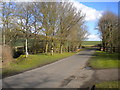
1
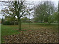
The Leys
An enclave of large detached houses where the developer could afford to leave large areas of open space.
Image: © Alan Murray-Rust
Taken: 11 Nov 2011
0.07 miles
2
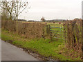
Field gateway on Clipston Lane
There are two items of note - firstly there is a bench mark http://www.geograph.org.uk/photo/3825902 on the left-hand gatepost, and secondly the grazing animals are alpacas.
Image: © Alan Murray-Rust
Taken: 24 Jan 2014
0.07 miles
3
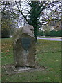
Millennium stone, Normanton
Essentially a village sign, there is a similar one at the far end of the village.
Image: © Alan Murray-Rust
Taken: 11 Nov 2011
0.07 miles
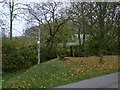
4
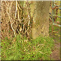
Gatepost with bench mark, Clipston Lane
The mark is pretty well concealed by the vegetation, and doubtless completely so when the leaves appear. The horizontal datum mark is just visible in the higher resolution image. See http://www.geograph.org.uk/photo/3825904 for location.
Image: © Alan Murray-Rust
Taken: 24 Jan 2014
0.08 miles
5
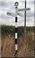
Old Direction Sign - Signpost by Cotgrave Road, Plumtree Parish
Annulus finial - 3 arms; Modern cast metal, small annular finial (NOTTS C C) by the UC road, in parish of Plumtree (Rushcliffe District), Normanton, Tollerton/ Plumtree boundary.
To be surveyed
Milestone Society National ID: NT_SK6133B
Image: © Milestone Society
Taken: Unknown
0.09 miles
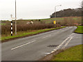
6
Clipston Lane north of Normanton
On the left, a public footpath heads off towards Tollerton.
Image: © Richard Vince
Taken: 27 Feb 2015
0.09 miles
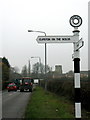
7
Clipston Lane junction, Normanton
The fingerpost is the modern version of the Nottinghamshire County Council cast iron model; the fingers are plastic rather than metal.
Image: © Alan Murray-Rust
Taken: 24 Jan 2014
0.09 miles
8
Footbridge off Clipston Lane
The start of a short footpath cutting off the angle to Cotgrave Road.
Image: © Alan Murray-Rust
Taken: 11 Nov 2011
0.10 miles
9
Fingerpost at Normanton
A modern version of the traditional Notts C.C. cast iron version. The lettering is generally smaller than the older style.
Plumtree Church in the distance.
Image: © Alan Murray-Rust
Taken: 11 Nov 2011
0.10 miles
10
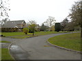
The Leys
An enclave of large detached houses where the developer could afford to leave large areas of open space.
Image: © Alan Murray-Rust
Taken: 11 Nov 2011
0.11 miles