IMAGES TAKEN NEAR TO
Roseland Close, NOTTINGHAM, NG12 5LQ
Introduction
This page details the photographs taken nearby to Roseland Close, NG12 5LQ by members of the Geograph project.
The Geograph project started in 2005 with the aim of publishing, organising and preserving representative images for every square kilometre of Great Britain, Ireland and the Isle of Man.

There are currently over 7.5m images from over14,400 individuals and you can help contribute to the project by visiting https://www.geograph.org.uk
Image Map
Images are licensed for reuse under creativecommons.org/licenses/by-sa/2.0
Notes
- Clicking on the map will re-center to the selected point.
- The higher the marker number, the further away the image location is from the centre of the postcode.
Image Listing (87 Images Found)
Images are licensed for reuse under creativecommons.org/licenses/by-sa/2.0
Image
Details
Distance
1
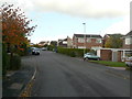
Brook View Drive
This is the main road through the 1970s development in the south-western sector of Keyworth.
Image: © Alan Murray-Rust
Taken: 1 Nov 2011
0.05 miles
2
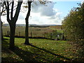
Footpath to Bunny
The footpath leaves the housing at this point to cross the fields to Bunny.
Image: © Alan Murray-Rust
Taken: 1 Nov 2011
0.05 miles
3
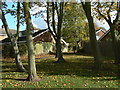
Open space off Brook View Drive
On the edge of the 1970s development in the south-eastern sector of the village.
Image: © Alan Murray-Rust
Taken: 1 Nov 2011
0.06 miles
4

Bunny Lane, Keyworth
Looking towards the centre of the village from the edge of housing development.
Image: © Alan Murray-Rust
Taken: 1 Nov 2011
0.07 miles
5
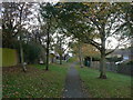
Estate footpath
The south-western corner of the village was developed in the modern idiom with pedestrian access separated as much as possible from vehicles. This path runs between Wright's Orchard and Brook View Drive.
Image: © Alan Murray-Rust
Taken: 1 Nov 2011
0.08 miles
6
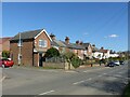
Bunnylane Cottages, Keyworth
This group of cottages was built in the late 19th centuries at some distance from the then edge of the village, only being joined to the village in the mid 20th century when the more distant housing in the view was developed. A feature of the row is the ornate cast iron railings along the property frontage.
There is a benchmark https://www.geograph.org.uk/photo/7119734 on the side of the house at this end of the row.
Image: © Alan Murray-Rust
Taken: 14 Mar 2022
0.10 miles
7
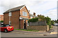
#64 Bunny Lane at High Court Drive junction
There is an OS benchmark Image on the near corner of the house left of the black downpipe
Image: © Roger Templeman
Taken: 14 Sep 2018
0.10 miles
8
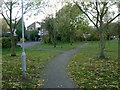
Estate footpath
The south-western corner of the village was developed in the 1970s/80s the modern idiom with pedestrian access separated as much as possible from vehicles. This path also maintains a traditional right of way which extends to the neighbouring village of Bunny.
Image: © Alan Murray-Rust
Taken: 1 Nov 2011
0.10 miles
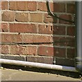
9
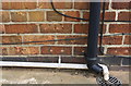
Benchmark on #64 Bunny Lane
Ordnance Survey cut mark benchmark described on the Bench Mark Database at https://www.bench-marks.org.uk/bm99811
Image: © Roger Templeman
Taken: 14 Sep 2018
0.10 miles
10
Bench Mark, 64 Bunny Lane, Keyworth
See https://www.geograph.org.uk/photo/7119737 for location.
Image: © Alan Murray-Rust
Taken: 14 Mar 2022
0.10 miles