IMAGES TAKEN NEAR TO
Debdale Lane, NOTTINGHAM, NG12 5HN
Introduction
This page details the photographs taken nearby to Debdale Lane, NG12 5HN by members of the Geograph project.
The Geograph project started in 2005 with the aim of publishing, organising and preserving representative images for every square kilometre of Great Britain, Ireland and the Isle of Man.

There are currently over 7.5m images from over14,400 individuals and you can help contribute to the project by visiting https://www.geograph.org.uk
Image Map
Images are licensed for reuse under creativecommons.org/licenses/by-sa/2.0
Notes
- Clicking on the map will re-center to the selected point.
- The higher the marker number, the further away the image location is from the centre of the postcode.
Image Listing (20 Images Found)
Images are licensed for reuse under creativecommons.org/licenses/by-sa/2.0
Image
Details
Distance
1

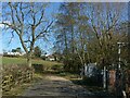
Debdale Lane Trading Estate
Much of modern Keyworth was developed as housing for miners at the neighbouring Cotgrave Colliery or for Nottingham commuters. This is one of the few recent developments to provide substitute employment in the village following the colliery closure.
Image: © Alan Murray-Rust
Taken: 1 Nov 2011
0.04 miles
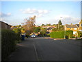
2

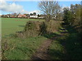
Debdale Lane
The undeveloped end of the lane just beyond the edge of housing development.
Image: © Alan Murray-Rust
Taken: 1 Nov 2011
0.04 miles
3

Gorse Road
The houses to the left are a much more recent addition to those on the right hand side, developed in the 1960s. At the time the picture was taken, they were not shown on the 1:25000 map.
Image: © Alan Murray-Rust
Taken: 1 Nov 2011
0.06 miles
4

Debdale Lane Sewage Pumping Station
This started out as a treatment plant to serve the expanding housing in the Debdale Lane area in the early part of the 20th century, but further development of the village meant that it became inadequate and a new works was established to the south of Bunny Lane. The plant here was then converted to a simple pumping station.
Image: © Alan Murray-Rust
Taken: 1 Nov 2011
0.07 miles
5
Debdale Lane, Keyworth
Recreating this 'First' for the square https://www.geograph.org.uk/photo/235553 . Surprisingly, the security fencing is now lower than it used to be!
Image: © Alan Murray-Rust
Taken: 14 Mar 2022
0.07 miles
6
The end of Debdale Lane
Looking back towards Keyworth. It's not clear whether this is still a public road at this point, although large scale OS maps suggest that it is, regardless of the surface.
Image: © Alan Murray-Rust
Taken: 1 Nov 2011
0.08 miles
7
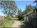
Debdale Lane, Keyworth
Track leading into Keyworth from the west. Pumping station on right
Image: © Tim Heaton
Taken: 8 Sep 2006
0.08 miles
8
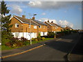
Houses at the west end of Hayes Road, Keyworth
Image: © Richard Vince
Taken: 15 Oct 2016
0.08 miles
10
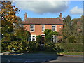
Melbourne Cottage, Debdale Lane
The area to the north of Debdale Lane was developed from the early 20th century with the increase of commuting into Nottingham, initially via the railway at Plumtree Station. This would have been one of the earliest houses to be built.
Image: © Alan Murray-Rust
Taken: 1 Nov 2011
0.11 miles