IMAGES TAKEN NEAR TO
Platt Lane, NOTTINGHAM, NG12 5GE
Introduction
This page details the photographs taken nearby to Platt Lane, NG12 5GE by members of the Geograph project.
The Geograph project started in 2005 with the aim of publishing, organising and preserving representative images for every square kilometre of Great Britain, Ireland and the Isle of Man.

There are currently over 7.5m images from over14,400 individuals and you can help contribute to the project by visiting https://www.geograph.org.uk
Image Map
Images are licensed for reuse under creativecommons.org/licenses/by-sa/2.0
Notes
- Clicking on the map will re-center to the selected point.
- The higher the marker number, the further away the image location is from the centre of the postcode.
Image Listing (32 Images Found)
Images are licensed for reuse under creativecommons.org/licenses/by-sa/2.0
Image
Details
Distance
1
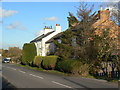
Shelton's Houses, Platt Lane
Originally attached to the former Shelton Farm.
Image: © Alan Murray-Rust
Taken: 1 Nov 2011
0.01 miles
2
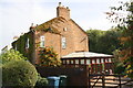
Willow Cottage, Platt Lane
Ordnance Survey documents indicate that in 1966 a benchmark levelled at 57.132m above Newlyn Datum was verified on the near corner, right hand face, of the house.
Image: © Roger Templeman
Taken: 14 Sep 2018
0.01 miles
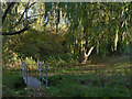
3

Pond at Spinners Croft
Created to absorb surface run-off from the new housing development.
Image: © Alan Murray-Rust
Taken: 17 Jan 2022
0.04 miles
4
Footbridge at the back of the British Geological Survey
A modern footbridge on an old established right of way.
Image: © Alan Murray-Rust
Taken: 1 Nov 2011
0.05 miles
5
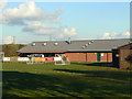
Keyworth United Community Football Club
A close view of the club house which comprises social facilities as well as changing rooms.
Image: © Alan Murray-Rust
Taken: 1 Nov 2011
0.06 miles
6
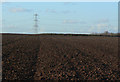
Modern ridge and furrow
The low November afternoon light shows how even modern plough techniques show how easily the ridges and furrows could develop by being repeatedly ploughed in the same pattern.
Image: © Alan Murray-Rust
Taken: 1 Nov 2011
0.07 miles
7
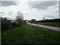
Platt Lane looking towards Keyworth
Image: © Jonathan Thacker
Taken: 8 Apr 2021
0.08 miles
8
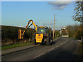
Hedging time
A traditional autumn agricultural task, although the equipment used has changed dramatically.
Image: © Alan Murray-Rust
Taken: 1 Nov 2011
0.09 miles
9
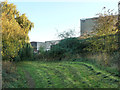
Footpath at the back of the Geological Survey
Someone has clearly made themselves responsible for maintaining the area.
Image: © Alan Murray-Rust
Taken: 1 Nov 2011
0.11 miles
10

Armstrong Road, Keyworth
Part of the new Spinners Croft housing development.
Image: © Alan Murray-Rust
Taken: 17 Jan 2022
0.14 miles