IMAGES TAKEN NEAR TO
The Ridings, NOTTINGHAM, NG12 5EF
Introduction
This page details the photographs taken nearby to The Ridings, NG12 5EF by members of the Geograph project.
The Geograph project started in 2005 with the aim of publishing, organising and preserving representative images for every square kilometre of Great Britain, Ireland and the Isle of Man.

There are currently over 7.5m images from over14,400 individuals and you can help contribute to the project by visiting https://www.geograph.org.uk
Image Map
Images are licensed for reuse under creativecommons.org/licenses/by-sa/2.0
Notes
- Clicking on the map will re-center to the selected point.
- The higher the marker number, the further away the image location is from the centre of the postcode.
Image Listing (21 Images Found)
Images are licensed for reuse under creativecommons.org/licenses/by-sa/2.0
Image
Details
Distance
3
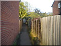
Footpath to The Ridings from Mount Pleasant, Keyworth
Image: © Richard Vince
Taken: 15 Oct 2016
0.05 miles
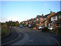
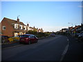
4
South end of Mount Pleasant, Keyworth
Image: © Richard Vince
Taken: 15 Oct 2016
0.11 miles
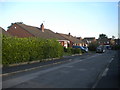
5
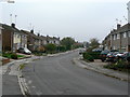
Fairway, Keyworth
This is the main spine road of the housing development on the east side of Keyworth.
Image: © Alan Murray-Rust
Taken: 11 Nov 2011
0.12 miles
6
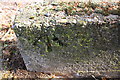
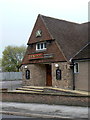
Benchmark on low wall at entrance to #100 Nicker Hill
Ordnance Survey rivet benchmark levelled at 87.084m above Newlyn Datum
Image: © Roger Templeman
Taken: 14 Sep 2018
0.15 miles
7
#100 Nicker Hill
There is an OS benchmark Image on the near end of the right hand low wall at the entrance drive to the house
Image: © Roger Templeman
Taken: 14 Sep 2018
0.15 miles
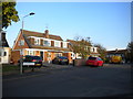
9
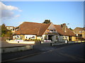
The Keyworth Tavern, Fairway, Keyworth
Image: © Richard Vince
Taken: 15 Oct 2016
0.16 miles
10
The Keywort
In fact The Keyworth Tavern, but a portion of the sign has gone missing.
Image: © Alan Murray-Rust
Taken: 11 Nov 2011
0.16 miles