IMAGES TAKEN NEAR TO
Melton Road, NOTTINGHAM, NG12 5BP
Introduction
This page details the photographs taken nearby to Melton Road, NG12 5BP by members of the Geograph project.
The Geograph project started in 2005 with the aim of publishing, organising and preserving representative images for every square kilometre of Great Britain, Ireland and the Isle of Man.

There are currently over 7.5m images from over14,400 individuals and you can help contribute to the project by visiting https://www.geograph.org.uk
Image Map
Images are licensed for reuse under creativecommons.org/licenses/by-sa/2.0
Notes
- Clicking on the map will re-center to the selected point.
- The higher the marker number, the further away the image location is from the centre of the postcode.
Image Listing (17 Images Found)
Images are licensed for reuse under creativecommons.org/licenses/by-sa/2.0
Image
Details
Distance
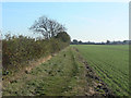
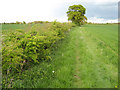
1
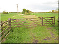
Bridleway to Fosse Way (1)
Remnant of an earlier network of routes is this bridleway, which is a direct continuation of Browns Lane.
Image: © Jonathan Wilkins
Taken: 12 May 2010
0.06 miles
2
Footpath closure notices
The closures referred to are those necessitated temporarily during the improvement works to the A46.
Image: © Alan Murray-Rust
Taken: 20 Oct 2011
0.07 miles
3
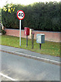
Browns Lane, Keyworth, postbox ref NG12 273
Standard EIIR lamp box. Presumably it or its predecessor was attached to the section of wooden post between it and the drop box, and it was too much trouble to remove the post when the change was made.
The box is referenced as Keyworth by Royal Mail, even thought it is clearly in Stanton-on-the-Wolds.
Image: © Alan Murray-Rust
Taken: 20 Oct 2011
0.07 miles
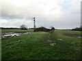
4
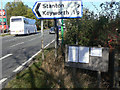
Bridleway towards the Foss Way
Currently closed at the far end due to the A46 improvement works, it will link to the new Roehope Junction layout.
Image: © Alan Murray-Rust
Taken: 20 Oct 2011
0.08 miles
5
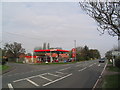
Petrol station at Stanton-on-the-Wolds
The busy A606 from Melton Mowbray to Nottingham skirts past Stanton-on-the-Wolds
Image: © Tim Heaton
Taken: 26 Apr 2006
0.09 miles
6
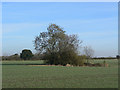
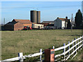
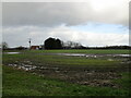
Pond near Bank Farm
This was probably created by the extraction of marl as field fertiliser.
Image: © Alan Murray-Rust
Taken: 20 Oct 2011
0.13 miles
9
Bridleway to Fosse Way (2)
Looking along the bridleway towards the Fosse Way. Not far beyond here the route was closed temporarily during construction of the new dual-carriageway road.
Image: © Jonathan Wilkins
Taken: 12 May 2010
0.18 miles