IMAGES TAKEN NEAR TO
Brook View Court, Main Street, NOTTINGHAM, NG12 5AS
Introduction
This page details the photographs taken nearby to Brook View Court, Main Street, NG12 5AS by members of the Geograph project.
The Geograph project started in 2005 with the aim of publishing, organising and preserving representative images for every square kilometre of Great Britain, Ireland and the Isle of Man.

There are currently over 7.5m images from over14,400 individuals and you can help contribute to the project by visiting https://www.geograph.org.uk
Image Map
Images are licensed for reuse under creativecommons.org/licenses/by-sa/2.0
Notes
- Clicking on the map will re-center to the selected point.
- The higher the marker number, the further away the image location is from the centre of the postcode.
Image Listing (94 Images Found)
Images are licensed for reuse under creativecommons.org/licenses/by-sa/2.0
Image
Details
Distance
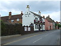
2
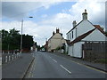
Main Street, Keyworth
A variety of activities on view. The pavement is being dressed with a new tarred surface; wheelie bins are out for collection; the bus is making its way along a tortuous route through the villages of south Nottinghamshire on its way from Newark via Bingham, Ruddington and the Queens Medical Centre to Beeston. (The route is split into three separate services, but the same bus works through, taking over 2½ hours for the complete journey).
Image: © Alan Murray-Rust
Taken: 1 Nov 2011
0.03 miles
3
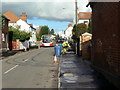
Main Street, Keyworth
Looking towards the church and The Square.
Image: © Kate Jewell
Taken: 17 Oct 2006
0.04 miles
4
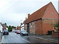
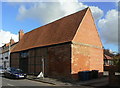
Old Barn in Keyworth
One of two Grade II listed barns in the village.
Image: © Geoff Pick
Taken: 3 Jul 2009
0.04 miles
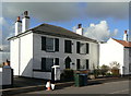
5
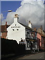
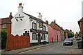
The Salutation
One of two pubs in the older part of the village, the other being The Plough http://www.geograph.org.uk/photo/1383925.
Image: © Alan Murray-Rust
Taken: 1 Nov 2011
0.05 miles
6
Martyn's Barn
One of the few Listed buildings (Grade II) in the village. Built in 1651 by local farmer George Martyn, details of its use are recorded on a commemorative plaque attached to the building http://www.geograph.org.uk/photo/2685066. Restored and converted to a dwelling.
Image: © Alan Murray-Rust
Taken: 1 Nov 2011
0.06 miles
7
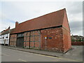
Barn, Main Street, Keyworth
Dates from 1651 though altered and extended since https://historicengland.org.uk/listing/the-list/list-entry/1373904
Image: © Jonathan Thacker
Taken: 8 Apr 2021
0.06 miles
8
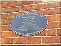
Commemorative plaque
Martyn's Barn can be seen in full in this image http://www.geograph.org.uk/photo/2685069.
Image: © Alan Murray-Rust
Taken: 1 Nov 2011
0.06 miles
9
The Salutation pub, Keyworth
On Main Street.
Image: © JThomas
Taken: 21 Jun 2014
0.06 miles
10
The Post House, Main Street
An attractive early 19th century house, specifically mentioned in the local conservation area document although not listed. The adjoining building to the right was formerly the post office.
Image: © Alan Murray-Rust
Taken: 1 Nov 2011
0.06 miles