IMAGES TAKEN NEAR TO
Wysall Lane, NOTTINGHAM, NG12 5AR
Introduction
This page details the photographs taken nearby to Wysall Lane, NG12 5AR by members of the Geograph project.
The Geograph project started in 2005 with the aim of publishing, organising and preserving representative images for every square kilometre of Great Britain, Ireland and the Isle of Man.

There are currently over 7.5m images from over14,400 individuals and you can help contribute to the project by visiting https://www.geograph.org.uk
Image Map
Images are licensed for reuse under creativecommons.org/licenses/by-sa/2.0
Notes
- Clicking on the map will re-center to the selected point.
- The higher the marker number, the further away the image location is from the centre of the postcode.
Image Listing (14 Images Found)
Images are licensed for reuse under creativecommons.org/licenses/by-sa/2.0
Image
Details
Distance
1
Wembley Lodge
On earlier maps simply shown as Lodge Farm.
Image: © Alan Murray-Rust
Taken: 1 Nov 2011
0.01 miles
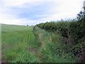
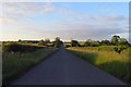
4
Wysall Lane
Heading north east towards Keyworth.
Image: © JThomas
Taken: 21 Jun 2014
0.16 miles
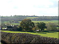
6
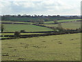
View from Wysall Lane
The road cuts the north western corner of the grid square, so most of the sunlit area is in the square. The distant farm is North Lodge Farm.
Image: © Alan Murray-Rust
Taken: 1 Nov 2011
0.18 miles
8
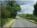
Wysall Lane
Heading north east towards Keyworth.
Image: © JThomas
Taken: 21 Jun 2014
0.22 miles
9
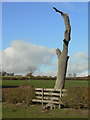
Decayed ash tree near Lings Lane
Pointing a ragged finger to the sky.
Image: © Alan Murray-Rust
Taken: 1 Nov 2011
0.22 miles
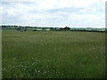
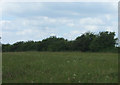
10
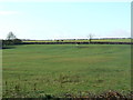
Pasture land below Keyworth
Showing signs of former ridge and furrow cultivation.
Image: © Alan Murray-Rust
Taken: 1 Nov 2011
0.23 miles