IMAGES TAKEN NEAR TO
Selby Lane, NOTTINGHAM, NG12 5AL
Introduction
This page details the photographs taken nearby to Selby Lane, NG12 5AL by members of the Geograph project.
The Geograph project started in 2005 with the aim of publishing, organising and preserving representative images for every square kilometre of Great Britain, Ireland and the Isle of Man.

There are currently over 7.5m images from over14,400 individuals and you can help contribute to the project by visiting https://www.geograph.org.uk
Image Map
Images are licensed for reuse under creativecommons.org/licenses/by-sa/2.0
Notes
- Clicking on the map will re-center to the selected point.
- The higher the marker number, the further away the image location is from the centre of the postcode.
Image Listing (88 Images Found)
Images are licensed for reuse under creativecommons.org/licenses/by-sa/2.0
Image
Details
Distance
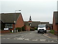
1
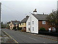
Selby Lane looking west
Housing from before the major expansion of housing in the inter-war period.
Image: © Alan Murray-Rust
Taken: 11 Nov 2011
0.02 miles
2
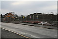
Former field, Keyworth
Too good to be true that this large green space should be left alone.
Image: © Chris
Taken: 12 Feb 2014
0.03 miles
4
Windmill Court
This replaced the original Board School, closed in 1985, and takes it name from the fact that the village windmill used to stand close to the site.
Image: © Alan Murray-Rust
Taken: 11 Nov 2011
0.04 miles
5
Windmill Court
This replaced the original Board School, closed in 1985, but from which the bell turret was rescued. It takes its name from the fact that the village windmill used to stand close to the site.
Image: © Alan Murray-Rust
Taken: 11 Nov 2011
0.04 miles
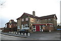
7
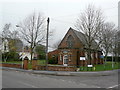
St. Mary Magdalene Parish Church Hall
Former Parochial School.
Image: © Chris
Taken: 12 Feb 2014
0.05 miles
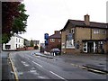
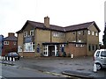
8
Morning after: The Plough
Still managing a warm glow in the cold light of an early February morning.
Image: © Chris
Taken: 12 Feb 2014
0.07 miles
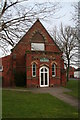
9
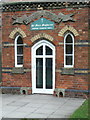
St Mary's Church Hall
Showing the fine stone banner over the entrance. See also http://www.geograph.org.uk/photo/2695960.
Image: © Alan Murray-Rust
Taken: 11 Nov 2011
0.07 miles
10
St Mary's Church Hall
Built in 1862 as the first purpose-built school in the village by the Parish Church, as a 'National' School. In 1874 a non-denominational 'Board School' was opened, funded by the local non-conformist churches, despite opposition from the Parish Church. It closed as a school shortly after and became the Parochial Church Hall. The inscribed stone banner over the entrance testifies to its original purpose http://www.geograph.org.uk/photo/2695963.
Image: © Alan Murray-Rust
Taken: 11 Nov 2011
0.07 miles