IMAGES TAKEN NEAR TO
Coralin Place, NG12 4LS
Introduction
This page details the photographs taken nearby to Coralin Place, NG12 4LS by members of the Geograph project.
The Geograph project started in 2005 with the aim of publishing, organising and preserving representative images for every square kilometre of Great Britain, Ireland and the Isle of Man.

There are currently over 7.5m images from over14,400 individuals and you can help contribute to the project by visiting https://www.geograph.org.uk
Image Map
Images are licensed for reuse under creativecommons.org/licenses/by-sa/2.0
Notes
- Clicking on the map will re-center to the selected point.
- The higher the marker number, the further away the image location is from the centre of the postcode.
Image Listing (4 Images Found)
Images are licensed for reuse under creativecommons.org/licenses/by-sa/2.0
Image
Details
Distance
1

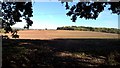
Footpath to Sharphill Wood
This does not appear on any current maps, but appears to well established, to such a degree that it should at the time of writing have been added to the definitive map as a right of way. The bush at the left hand side is adjacent to a depression which was probably a marl pit.
Image: © Alan Murray-Rust
Taken: 23 Sep 2008
0.20 miles
2
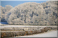
Sharphill Wood
From the strange stub of road seen in Image
This was taken about 1 p.m. the temperature was approximately -3.5C.
Image: © David Lally
Taken: 7 Dec 2010
0.22 miles
3
Path from Old Road on Wilford Hill
Recently cultivated and not clear to see.
Image: © Chris Morgan
Taken: 25 Sep 2018
0.23 miles
4
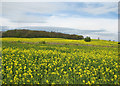
Edwalton: towards Sharphill Wood
A view across a field of oilseed rape next to the A606, taken on the morning of the May Day Bank Holiday.
Image: © John Sutton
Taken: 2 May 2016
0.23 miles