IMAGES TAKEN NEAR TO
Fowler Road, NOTTINGHAM, NG12 4JS
Introduction
This page details the photographs taken nearby to Fowler Road, NG12 4JS by members of the Geograph project.
The Geograph project started in 2005 with the aim of publishing, organising and preserving representative images for every square kilometre of Great Britain, Ireland and the Isle of Man.

There are currently over 7.5m images from over14,400 individuals and you can help contribute to the project by visiting https://www.geograph.org.uk
Image Map
Images are licensed for reuse under creativecommons.org/licenses/by-sa/2.0
Notes
- Clicking on the map will re-center to the selected point.
- The higher the marker number, the further away the image location is from the centre of the postcode.
Image Listing (8 Images Found)
Images are licensed for reuse under creativecommons.org/licenses/by-sa/2.0
Image
Details
Distance
1
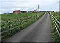
Edwalton: the road to Lodge Farm
Houses are to be built on this land.
Image: © John Sutton
Taken: 2 May 2016
0.06 miles
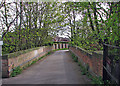
2
Edwalton: Midland Railway bridge parapets
The Midland main line between Nottingham and Melton closed in the 1960s. This bridge, carrying Machins Lane to Lodge Farm (ahead), has been filled in. The railway's course from here to Melton Road in West Bridgford is now a footpath and nature reserve, The Green Line.
Image: © John Sutton
Taken: 2 May 2016
0.12 miles
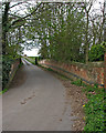
3
Edwalton: once a railway bridge
The Midland main line between Nottingham and Melton closed in the 1960s. This bridge, carrying Machins Lane to Lodge Farm (behind the camera), has been filled in. The railway's course from here to Melton Road in West Bridgford is now a footpath and nature reserve, The Green Line.
Image: © John Sutton
Taken: 2 May 2016
0.13 miles
4
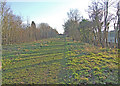
Former trackbed of the railway between Nottingham and Melton
Image: © Tim Glover
Taken: 31 May 2009
0.14 miles
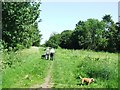
5
Re-used railway
Former railway cutting which appears to have been filled in to form a public footpath.
Image: © Dennis Turner
Taken: 26 Dec 2008
0.21 miles
6
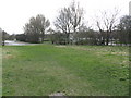
The Railway Children?
A leisure centre (in the background) and a school occupy the old railway formation, which is also used as a linear footpath.
Image: © Peter Whatley
Taken: 22 Mar 2009
0.24 miles
8
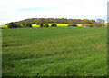
Edwalton: fields on the southern edge of Nottingham
Sharphill Wood is on the skyline.
Image: © John Sutton
Taken: 2 May 2016
0.25 miles