IMAGES TAKEN NEAR TO
Wheatcroft Drive, NOTTINGHAM, NG12 4JF
Introduction
This page details the photographs taken nearby to Wheatcroft Drive, NG12 4JF by members of the Geograph project.
The Geograph project started in 2005 with the aim of publishing, organising and preserving representative images for every square kilometre of Great Britain, Ireland and the Isle of Man.

There are currently over 7.5m images from over14,400 individuals and you can help contribute to the project by visiting https://www.geograph.org.uk
Image Map
Images are licensed for reuse under creativecommons.org/licenses/by-sa/2.0
Notes
- Clicking on the map will re-center to the selected point.
- The higher the marker number, the further away the image location is from the centre of the postcode.
Image Listing (23 Images Found)
Images are licensed for reuse under creativecommons.org/licenses/by-sa/2.0
Image
Details
Distance
1
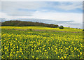
Edwalton: towards Sharphill Wood
A view across a field of oilseed rape next to the A606, taken on the morning of the May Day Bank Holiday.
Image: © John Sutton
Taken: 2 May 2016
0.02 miles
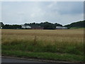
2
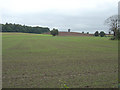
Fields alongside Melton Road
Looking towards Sharp Hill
Image: © Alan Murray-Rust
Taken: 23 Sep 2008
0.04 miles
3
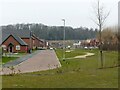
Sunflower Drive, Edwalton Fields
This is on the site of the former Wheatcroft nurseries, and roads are named after flowers in token of that. Sharphill Wood in the distance.
Image: © Alan Murray-Rust
Taken: 23 Jan 2022
0.11 miles
4
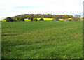
Edwalton: fields on the southern edge of Nottingham
Sharphill Wood is on the skyline.
Image: © John Sutton
Taken: 2 May 2016
0.13 miles
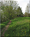
6
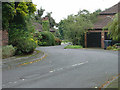
Hill Farm Court
A public footpath passes through here.
Image: © Alan Murray-Rust
Taken: 23 Sep 2008
0.16 miles
7
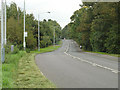
Melton Road near Edwalton
Still a busy road, although through traffic is now routed via Lings Bar Road.
Image: © Alan Murray-Rust
Taken: 23 Sep 2008
0.16 miles
9

Balancing pond, Edwalton Fields
This appears to have been deliberately developed more as wetland than pond.
Image: © Alan Murray-Rust
Taken: 23 Jan 2022
0.19 miles
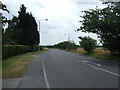
10
Edwalton: footpath near Hill Farm
A stretch of the network of paths linking Tollerton, Edwalton and Ruddington. The sun was just breaking through on a cloudy Bank Holiday Monday morning - but the afternoon was rainy.
Image: © John Sutton
Taken: 2 May 2016
0.20 miles