IMAGES TAKEN NEAR TO
Tollerton Lane, NOTTINGHAM, NG12 4GB
Introduction
This page details the photographs taken nearby to Tollerton Lane, NG12 4GB by members of the Geograph project.
The Geograph project started in 2005 with the aim of publishing, organising and preserving representative images for every square kilometre of Great Britain, Ireland and the Isle of Man.

There are currently over 7.5m images from over14,400 individuals and you can help contribute to the project by visiting https://www.geograph.org.uk
Image Map
Images are licensed for reuse under creativecommons.org/licenses/by-sa/2.0
Notes
- Clicking on the map will re-center to the selected point.
- The higher the marker number, the further away the image location is from the centre of the postcode.
Image Listing (23 Images Found)
Images are licensed for reuse under creativecommons.org/licenses/by-sa/2.0
Image
Details
Distance
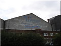
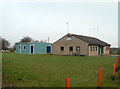
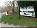
1
Old frontage, Nottingham Airport
Fronting onto Tollerton Lane, showing evidence of various ownerships. Vehicular access is now a little way to the south.
Image: © Richard Vince
Taken: 13 Aug 2016
0.04 miles
2
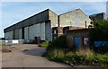
Old hangar at Nottingham City Airport
The hangar was demolished in 2017.
Image: © Mat Fascione
Taken: 6 Oct 2013
0.04 miles
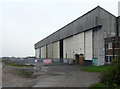
4
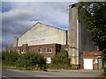
Nottingham Airport (Tollerton)
The old hangar and admin buildings. The painted signs on the hangar are relics of the time when it was hoped to develop Tollerton for commercial flights. The hangar is no longer used for aviation purposes.
Image: © Alan Murray-Rust
Taken: 13 Nov 2011
0.04 miles
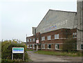
5
Air Training Corps unit
Housing the 2425 (Nottingham Airport) Squadron.
Image: © Alan Murray-Rust
Taken: 13 Nov 2011
0.06 miles
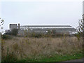
6
Hangar at Nottingham Airport (Tollerton)
This is the remaining wartime hangar, no longer used for flying purposes. It houses the local branch of a large Birmingham-based vehicle recovery company.
Image: © Alan Murray-Rust
Taken: 13 Nov 2011
0.07 miles
7
Hangar at Nottingham Airport
View from the south, from the current access road to the airfield.
Image: © Alan Murray-Rust
Taken: 13 Nov 2011
0.07 miles
8
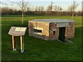
Pillbox at Tollerton Airfield
One of the 18 Grade II Listed pillboxes built c.1940 as perimeter defence of the airfield. The information board explains that it was unusual for an inland airfield to have a defensive perimeter on this scale, but Tollerton had a role as Field Repair Unit and therefore had large numbers of aircraft on site. This pillbox is a standard type FW3/22, listed on the Defence of Britain database as S0000652 where it is incorrectly identified as type FW3/24. It was repaired in 2017 by Spire Healthcare as part of the development of their new hospital https://www.geograph.org.uk/photo/7074635
Image: © Alan Murray-Rust
Taken: 17 Jan 2022
0.08 miles
9
Tollerton Airport postbox ref NG12 48
Standard freestanding E II R lamp box.
Image: © Alan Murray-Rust
Taken: 13 Nov 2011
0.09 miles
10
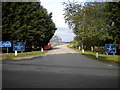
Vehicular entrance to Nottingham Airport
An airfield for general aviation rather than a commercial airport as such, Nottingham Airport also doubles as a business park of sorts, hence the building under construction on the left. The signs welcome visitors to "Nottingham City Airport", presumably to differentiate it from East Midlands Airport when the latter had "Nottingham" appended to the front of its name.
Image: © Richard Vince
Taken: 13 Aug 2016
0.09 miles