IMAGES TAKEN NEAR TO
Croft Road, NOTTINGHAM, NG12 4BW
Introduction
This page details the photographs taken nearby to Croft Road, NG12 4BW by members of the Geograph project.
The Geograph project started in 2005 with the aim of publishing, organising and preserving representative images for every square kilometre of Great Britain, Ireland and the Isle of Man.

There are currently over 7.5m images from over14,400 individuals and you can help contribute to the project by visiting https://www.geograph.org.uk
Image Map
Images are licensed for reuse under creativecommons.org/licenses/by-sa/2.0
Notes
- Clicking on the map will re-center to the selected point.
- The higher the marker number, the further away the image location is from the centre of the postcode.
Image Listing (15 Images Found)
Images are licensed for reuse under creativecommons.org/licenses/by-sa/2.0
Image
Details
Distance
1
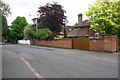
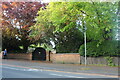
#14 Valley Road
Behind new walls and gates
Image: © Roger Templeman
Taken: 12 May 2018
0.09 miles
2
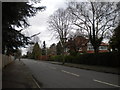
South end of Trevor Road, West Bridgford
Image: © Richard Vince
Taken: 8 Feb 2014
0.11 miles
4
#28 Valley Road
There is an OS benchmark Image on the right hand side of an outbuilding partly hidden by trees to the left of wheelie bins
Image: © Roger Templeman
Taken: 12 May 2018
0.14 miles
5
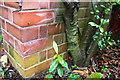
Benchmark on outbuilding at #28 Valley Road
Ordnance Survey cut mark benchmark described on the Bench Mark Database at https://www.bench-marks.org.uk/bm102410
Image: © Roger Templeman
Taken: 12 May 2018
0.14 miles
9
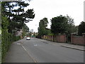
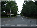
Melton Road, Edwalton
There are houses there but you can't see them past the trees.
Image: © David Howard
Taken: 8 May 2022
0.19 miles
10
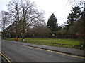
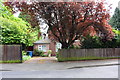
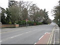
Site of Valley Road bus turning circle, West Bridgford (1)
Now a small open space off Valley Road (foreground). The turning circle here was the terminus of the former West Bridgford Urban District Council's Melton Road bus service, and after that undertaking's bus services were taken over by Nottingham City Transport, the Musters Road route was extended here too. Today, those routes extend to Gamston and turn at Rushcliffe Leisure Centre respectively, leaving no need for a turning circle here.
Image: © Richard Vince
Taken: 8 Feb 2014
0.19 miles