IMAGES TAKEN NEAR TO
Manor Close, NOTTINGHAM, NG12 4BH
Introduction
This page details the photographs taken nearby to Manor Close, NG12 4BH by members of the Geograph project.
The Geograph project started in 2005 with the aim of publishing, organising and preserving representative images for every square kilometre of Great Britain, Ireland and the Isle of Man.

There are currently over 7.5m images from over14,400 individuals and you can help contribute to the project by visiting https://www.geograph.org.uk
Image Map
Images are licensed for reuse under creativecommons.org/licenses/by-sa/2.0
Notes
- Clicking on the map will re-center to the selected point.
- The higher the marker number, the further away the image location is from the centre of the postcode.
Image Listing (20 Images Found)
Images are licensed for reuse under creativecommons.org/licenses/by-sa/2.0
Image
Details
Distance
1
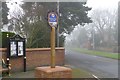
Edwalton Village sign
At the junction of Village Street and Wellin Lane. New since the last time I was around this way.
Image: © David Lally
Taken: 10 Jan 2013
0.11 miles
2
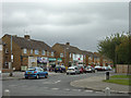
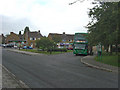
Earlswood Drive
A small shopping parade developed as part of the council-developed estate.
Image: © Alan Murray-Rust
Taken: 23 Sep 2008
0.12 miles
3
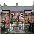
Edwalton: the gate of the Hind Almshouses
These almshouses were built in 1927 by Oliver Hind of Edwalton Hall, in memory of his parents and of his brother and a nephew, both of whom were killed on The Somme.
Image: © John Sutton
Taken: 25 Sep 2013
0.12 miles
4
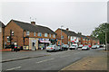
Edwalton: shops on Earlswood Drive
Newsagent, chemist and Post Office near the Wellin Lane bus terminus.
Image: © John Sutton
Taken: 25 Sep 2013
0.13 miles
5
Edwalton: the Hind Almshouses
These almshouses were built in 1927 by Oliver Hind of Edwalton Hall. Plaques either side of the gate record that they were built in memory of his parents and of his brother, Lt Col Lawrence Hind MC, killed leading his battalion on the first day of The Somme, and a nephew, Lt Jesse Hind, wounded at Gallipoli and killed at Thiepval on The Somme.
Image: © John Sutton
Taken: 25 Sep 2013
0.13 miles
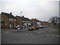
6
Edwalton Bus Terminus
At the junction of Wellin Lane and Earlswood Drive. A useful group of local shops includes a small supermarket, a Post Office and a newsagent.
Image: © Alan Murray-Rust
Taken: 23 Sep 2008
0.14 miles
8
Edwalton: Wellin Lane bus terminus
The terminus of the No 6 route. The Nottingham City Transport bus is painted in the old West Bridgford livery to mark a hundred years of buses to Bridgford. It has shared this service with green NCT buses throughout the year. For more about this bus, see Image
Image: © John Sutton
Taken: 17 Sep 2014
0.15 miles
9
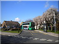
Wellin Lane terminus, Edwalton
The bus turning circle on Wellin Lane, Edwalton, complete with bus (operating route 6 from Nottingham city centre via West Bridgford). This is one of the more pleasant outer termini in greater Nottingham, particularly on fine spring days when the trees are covered in blossom.
Image: © Richard Vince
Taken: 21 Mar 2011
0.15 miles
10
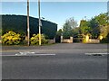
Melton Road, Edwalton
Many of the houses along this road are gated and hidden by trees and hedges.
Image: © David Howard
Taken: 8 May 2022
0.15 miles