IMAGES TAKEN NEAR TO
Village Street, NOTTINGHAM, NG12 4AE
Introduction
This page details the photographs taken nearby to Village Street, NG12 4AE by members of the Geograph project.
The Geograph project started in 2005 with the aim of publishing, organising and preserving representative images for every square kilometre of Great Britain, Ireland and the Isle of Man.

There are currently over 7.5m images from over14,400 individuals and you can help contribute to the project by visiting https://www.geograph.org.uk
Image Map
Images are licensed for reuse under creativecommons.org/licenses/by-sa/2.0
Notes
- Clicking on the map will re-center to the selected point.
- The higher the marker number, the further away the image location is from the centre of the postcode.
Image Listing (69 Images Found)
Images are licensed for reuse under creativecommons.org/licenses/by-sa/2.0
Image
Details
Distance
1
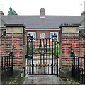
Edwalton: the gate of the Hind Almshouses
These almshouses were built in 1927 by Oliver Hind of Edwalton Hall, in memory of his parents and of his brother and a nephew, both of whom were killed on The Somme.
Image: © John Sutton
Taken: 25 Sep 2013
0.05 miles
2
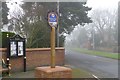
Edwalton Village sign
At the junction of Village Street and Wellin Lane. New since the last time I was around this way.
Image: © David Lally
Taken: 10 Jan 2013
0.05 miles
3
Edwalton: the Hind Almshouses
These almshouses were built in 1927 by Oliver Hind of Edwalton Hall. Plaques either side of the gate record that they were built in memory of his parents and of his brother, Lt Col Lawrence Hind MC, killed leading his battalion on the first day of The Somme, and a nephew, Lt Jesse Hind, wounded at Gallipoli and killed at Thiepval on The Somme.
Image: © John Sutton
Taken: 25 Sep 2013
0.05 miles
4
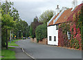
Village Street, Edwalton
The cottages on the right are among the few surviving buildings from the old village of Edwalton.
Image: © Alan Murray-Rust
Taken: 23 Sep 2008
0.14 miles
5
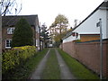
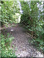
Public footpath off Village Street, Edwalton
Also a driveway for some houses.
Image: © Richard Vince
Taken: 29 Nov 2014
0.14 miles
7
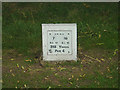
Tee marker
7th and 16th hole, Edwalton Golf Course. This is a 9 hole course so has to be traversed twice for a full 18 hole round.
Image: © Alan Murray-Rust
Taken: 23 Sep 2008
0.16 miles
8
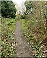
Footpath at Edwalton
Recreating this 'First' for the square https://www.geograph.org.uk/photo/229031
Image: © Alan Murray-Rust
Taken: 23 Jan 2022
0.17 miles
9
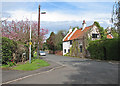
Edwalton: Village Street
Edwalton is largely a modern suburb. This is the centre of what was once a typical South Notts village.
Image: © John Sutton
Taken: 2 May 2016
0.17 miles
10
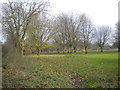
Footpath at Edwalton
The land on both sides of the footpath dips down as it crosses a former railway line. The gate at the end leads to Edwalton Golf Course.
Image: © Catherine Davis
Taken: 30 Aug 2006
0.17 miles