IMAGES TAKEN NEAR TO
Woodgate Lane, NOTTINGHAM, NG12 3UT
Introduction
This page details the photographs taken nearby to Woodgate Lane, NG12 3UT by members of the Geograph project.
The Geograph project started in 2005 with the aim of publishing, organising and preserving representative images for every square kilometre of Great Britain, Ireland and the Isle of Man.

There are currently over 7.5m images from over14,400 individuals and you can help contribute to the project by visiting https://www.geograph.org.uk
Image Map
Images are licensed for reuse under creativecommons.org/licenses/by-sa/2.0
Notes
- Clicking on the map will re-center to the selected point.
- The higher the marker number, the further away the image location is from the centre of the postcode.
Image Listing (5 Images Found)
Images are licensed for reuse under creativecommons.org/licenses/by-sa/2.0
Image
Details
Distance
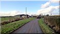
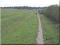
2
Woodgate Lane
An old field access lane, still in use as a public footpath which leads through to the Grantham Canal towpath here http://www.geograph.org.uk/photo/1622508
Image: © Alan Murray-Rust
Taken: 20 Oct 2011
0.18 miles
3
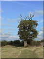
Declining oak tree
Although still showing a significant amount of leaf canopy, this tree has lost its high canopy and much of the bark on the main trunk.
Image: © Alan Murray-Rust
Taken: 20 Oct 2011
0.20 miles
4
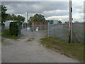
Cotgrave Sewage Treatment works
The lower of the two entrances to the works, on Woodgate Lane.
Image: © Alan Murray-Rust
Taken: 20 Oct 2011
0.23 miles
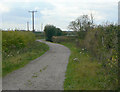
5
Field footpath near Cotgrave
This shows evidence of remarkably heavy traffic for a relatively ordinary field path.
Image: © Alan Murray-Rust
Taken: 20 Oct 2011
0.25 miles