IMAGES TAKEN NEAR TO
Greengage Road, NOTTINGHAM, NG12 3SY
Introduction
This page details the photographs taken nearby to Greengage Road, NG12 3SY by members of the Geograph project.
The Geograph project started in 2005 with the aim of publishing, organising and preserving representative images for every square kilometre of Great Britain, Ireland and the Isle of Man.

There are currently over 7.5m images from over14,400 individuals and you can help contribute to the project by visiting https://www.geograph.org.uk
Image Map
Images are licensed for reuse under creativecommons.org/licenses/by-sa/2.0
Notes
- Clicking on the map will re-center to the selected point.
- The higher the marker number, the further away the image location is from the centre of the postcode.
Image Listing (48 Images Found)
Images are licensed for reuse under creativecommons.org/licenses/by-sa/2.0
Image
Details
Distance
1
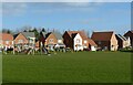
Harvest Drive Play Area, Hollygate, Cotgrave
One of several open spaces in this new housing development.
Image: © Alan Murray-Rust
Taken: 9 Jan 2022
0.05 miles
2
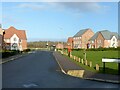
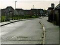
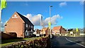
Harvest Drive, Hollygate, Cotgrave
The main spine road through this new housing development.
Image: © Alan Murray-Rust
Taken: 9 Jan 2022
0.08 miles
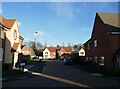
3
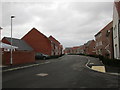
Maygreen Avenue
Avenue in name only.
Image: © Jonathan Thacker
Taken: 3 Feb 2017
0.08 miles
4
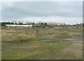
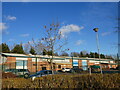
Cotgrave Colliery site
Most of the area of the colliery working area is still waste ground, although a small industrial estate has been created.
Image: © Alan Murray-Rust
Taken: 13 Dec 2009
0.08 miles
5
Cotgrave colliery site
Recreating this 'First' for the square http://www.geograph.org.uk/photo/195894 , now completely changed by the presence of the new Hollygate housing development. The location has been established by reference to historic satellite views on Google Earth. Fortunately it proved to be on the line of the new road rather than under someone's house!
Image: © Alan Murray-Rust
Taken: 9 Jan 2022
0.09 miles
7
Footpath off Maygreen Avenue
This is part of the Hollygate Park development.
Image: © Jonathan Thacker
Taken: 3 Feb 2017
0.11 miles
9
Barratt new homes at Hollygate Park, Cotgrave
Image: © Chris Morgan
Taken: 7 Feb 2017
0.11 miles
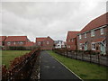
10
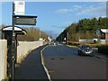
Harvest Drive, Hollygate, Cotgrave
Unusually, a new housing development for which public transport provision has been made at an early stage of development. The road layout has enabled the diversion of an existing service between Nottingham and the Cropwells with little extra mileage.
Image: © Alan Murray-Rust
Taken: 9 Jan 2022
0.12 miles