IMAGES TAKEN NEAR TO
Miller Hives Close, NOTTINGHAM, NG12 3QY
Introduction
This page details the photographs taken nearby to Miller Hives Close, NG12 3QY by members of the Geograph project.
The Geograph project started in 2005 with the aim of publishing, organising and preserving representative images for every square kilometre of Great Britain, Ireland and the Isle of Man.

There are currently over 7.5m images from over14,400 individuals and you can help contribute to the project by visiting https://www.geograph.org.uk
Image Map
Images are licensed for reuse under creativecommons.org/licenses/by-sa/2.0
Notes
- Clicking on the map will re-center to the selected point.
- The higher the marker number, the further away the image location is from the centre of the postcode.
Image Listing (74 Images Found)
Images are licensed for reuse under creativecommons.org/licenses/by-sa/2.0
Image
Details
Distance
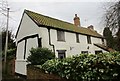
1
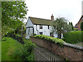
1 Church Lane, Cotgrave
Mid 17th century timber framed cottage with 18th and 19th century alterations. Listed Grade II.
Image: © Alan Murray-Rust
Taken: 27 Apr 2014
0.04 miles
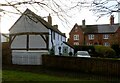
2
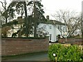
The Old Rectory, Cotgrave
Early 19th century house with modern extension at the far end. Listed Grade II.
Image: © Alan Murray-Rust
Taken: 9 Jan 2022
0.04 miles
3
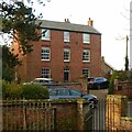
The Limes, Church Lane, Cotgrave
Early 19th century, probably originally a farmhouse, Listed Grade II.
Image: © Alan Murray-Rust
Taken: 9 Jan 2022
0.05 miles
4
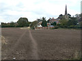
Footpath re-established
The farmer has clearly used a tractor to mark the path, but only one of the ruts has been used.
Image: © Alan Murray-Rust
Taken: 20 Oct 2011
0.05 miles
5
1 Church Lane, Cotgrave
Has the remains of a timber frame http://www.britishlistedbuildings.co.uk/en-430460-1-church-lane-cotgrave-nottinghamshire#.WJemsX-q-Tw
Image: © Jonathan Thacker
Taken: 3 Feb 2017
0.05 miles
6
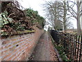
Footpath alongside the churchyard, Cotgrave
Links Plumtree Road to Church Lane.
Image: © Jonathan Thacker
Taken: 3 Feb 2017
0.05 miles
7
1 Church Lane, Cotgrave
This cottage dates back to the 17th century, with the exposed timbers dating from this period, but much altered in the 19th and 20th centuries. Listed Grade II.
Image: © Alan Murray-Rust
Taken: 9 Jan 2022
0.05 miles
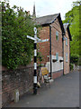
8
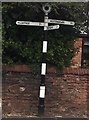
Old Direction Sign - Signpost in Cotgrave
Annulus finial - 3 arms; Modern NOTTS CC post, by the UC road, in parish of Cotgrave (Rushcliffe District), Plumtree Road junction with Scrimshire Lane, Cotgrave.
Surveyed
Milestone Society National ID: NT_SK6435B
Image: © Milestone Society
Taken: Unknown
0.05 miles
9
Fingerpost, Plumtree Road/Scrimshire Lane, Cotgrave
Modern Notts CC fingerpost (steel with cast aluminium fingers and finial) in traditional style.
Image: © Alan Murray-Rust
Taken: 27 Apr 2014
0.05 miles
10
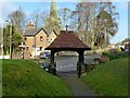
The lych gate, Cotgrave cemetery
The cemetery was inaugurated in 1899 as an extension to the churchyard, funded by the 3rd Earl Manvers. The lych gate oak timbers were sourced from Sherwood Forest. Gate and walls are Listed Grade II.
Image: © Alan Murray-Rust
Taken: 9 Jan 2022
0.06 miles