IMAGES TAKEN NEAR TO
Spinney Close, NOTTINGHAM, NG12 3QE
Introduction
This page details the photographs taken nearby to Spinney Close, NG12 3QE by members of the Geograph project.
The Geograph project started in 2005 with the aim of publishing, organising and preserving representative images for every square kilometre of Great Britain, Ireland and the Isle of Man.

There are currently over 7.5m images from over14,400 individuals and you can help contribute to the project by visiting https://www.geograph.org.uk
Image Map
Images are licensed for reuse under creativecommons.org/licenses/by-sa/2.0
Notes
- Clicking on the map will re-center to the selected point.
- The higher the marker number, the further away the image location is from the centre of the postcode.
Image Listing (6 Images Found)
Images are licensed for reuse under creativecommons.org/licenses/by-sa/2.0
Image
Details
Distance
1
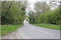
Owthorpe Road, Cotgrave
The road drops over 50 metres as it descends Wolds Hill. Cotgrave straight ahead.
Image: © Kate Jewell
Taken: 30 Apr 2006
0.12 miles
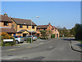
2
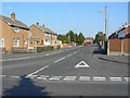
Ring Leas
This is the main distributor road through the large housing development on the south side of Cotgrave built to house workers from the new Cotgrave Colliery which started production in 1964. This is the western end where it joins Owthorpe Road.
Image: © Alan Murray-Rust
Taken: 3 Oct 2011
0.14 miles
4
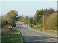
Owthorpe Road
Looking north, with the spire of Cotgrave Church just visible.
Image: © Alan Murray-Rust
Taken: 3 Oct 2011
0.21 miles
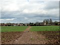
5
Gripps Common
This was the final area of residential development in this part of Cotgrave.
Image: © Alan Murray-Rust
Taken: 3 Oct 2011
0.22 miles
6
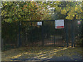
Welcome to Ring Leas Play area
. . . Or maybe not, to judge by the barrier.
Image: © Alan Murray-Rust
Taken: 3 Oct 2011
0.23 miles