IMAGES TAKEN NEAR TO
Flagholme, NOTTINGHAM, NG12 3PE
Introduction
This page details the photographs taken nearby to Flagholme, NG12 3PE by members of the Geograph project.
The Geograph project started in 2005 with the aim of publishing, organising and preserving representative images for every square kilometre of Great Britain, Ireland and the Isle of Man.

There are currently over 7.5m images from over14,400 individuals and you can help contribute to the project by visiting https://www.geograph.org.uk
Image Map
Images are licensed for reuse under creativecommons.org/licenses/by-sa/2.0
Notes
- Clicking on the map will re-center to the selected point.
- The higher the marker number, the further away the image location is from the centre of the postcode.
Image Listing (25 Images Found)
Images are licensed for reuse under creativecommons.org/licenses/by-sa/2.0
Image
Details
Distance
1
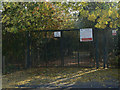
Welcome to Ring Leas Play area
. . . Or maybe not, to judge by the barrier.
Image: © Alan Murray-Rust
Taken: 3 Oct 2011
0.07 miles
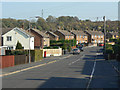
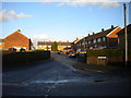
2
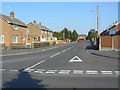
Ring Leas
This is the main distributor road through the large housing development on the south side of Cotgrave built to house workers from the new Cotgrave Colliery which started production in 1964. This is the western end where it joins Owthorpe Road.
Image: © Alan Murray-Rust
Taken: 3 Oct 2011
0.08 miles
3
Cartbridge, Cotgrave
A residential cul de sac off Ring Leas.
Image: © Richard Vince
Taken: 24 Feb 2015
0.09 miles
4
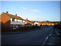
Ring Leas, Cotgrave
A distributor road around the southern and eastern sides of the village, serving housing constructed to house miners at Cotgrave Colliery.
Image: © Richard Vince
Taken: 24 Feb 2015
0.10 miles
5
Ring Leas
Looking southeast from near Cartbridge. The distant woodland is Cotgrave Gorse.
Image: © Alan Murray-Rust
Taken: 3 Oct 2011
0.11 miles
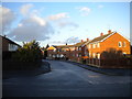
6
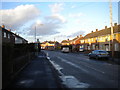
South end of Woodview, Cotgrave
Looking towards the village centre from the junction with Ring Leas.
Image: © Richard Vince
Taken: 24 Feb 2015
0.12 miles
7
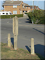
Barton bus stop
This odd looking concrete post was a design of bus stop pole specific to the local bus operator, Barton Transport.
At one time the largest independent* operator of bus services in the UK, it even had its own concrete casting plant where these distinctive posts were produced. Timetable panels would be attached to the flat areas. Their demise really started when a nationally agreed standard for bus stops was introduced in the 1970s, requiring a plate with a standard bus logo to be displayed to enable parking restrictions at bus stops to be enforceable. 40 years on a small number of these sturdy objects still survive.
* i.e. not belonging to a Local Authority or one of the nationalised companies
Image: © Alan Murray-Rust
Taken: 3 Oct 2011
0.13 miles
8
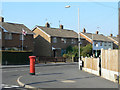
Ring Leas postbox ref no NG12 284
E II R pillar box on the corner of Woodview.
Image: © Alan Murray-Rust
Taken: 3 Oct 2011
0.13 miles
9
Little Meadow, Cotgrave
A residential cul de sac off Woodview.
Image: © Richard Vince
Taken: 24 Feb 2015
0.13 miles
10
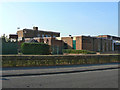
Cotgrave Welfare
A reminder of the fact that Cotgrave developed to serve the colliery opened in 1963.
Image: © Alan Murray-Rust
Taken: 3 Oct 2011
0.13 miles