IMAGES TAKEN NEAR TO
Hickling Way, NOTTINGHAM, NG12 3NY
Introduction
This page details the photographs taken nearby to Hickling Way, NG12 3NY by members of the Geograph project.
The Geograph project started in 2005 with the aim of publishing, organising and preserving representative images for every square kilometre of Great Britain, Ireland and the Isle of Man.

There are currently over 7.5m images from over14,400 individuals and you can help contribute to the project by visiting https://www.geograph.org.uk
Image Map
Images are licensed for reuse under creativecommons.org/licenses/by-sa/2.0
Notes
- Clicking on the map will re-center to the selected point.
- The higher the marker number, the further away the image location is from the centre of the postcode.
Image Listing (13 Images Found)
Images are licensed for reuse under creativecommons.org/licenses/by-sa/2.0
Image
Details
Distance
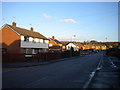
1
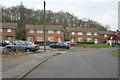
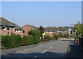
National Coal Board Housing, Cotgrave
These houses on Ring Leas are typical of this estate. The mine was closed in the 1980s and since then the houses have been sold off and they are becoming more individual in character. The extent of the estate was determined by the steep contours to the east and south of the village. Here the trees of Cotgrave Gorse clothe the hillside.
Image: © Kate Jewell
Taken: 30 Apr 2006
0.17 miles
2
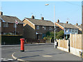
Ring Leas postbox ref no NG12 284
E II R pillar box on the corner of Woodview.
Image: © Alan Murray-Rust
Taken: 3 Oct 2011
0.20 miles
4
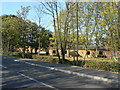
Eton Park
Residential care home - with nursing - on the outskirts of Cotgrave.
Image: © Alan Murray-Rust
Taken: 3 Oct 2011
0.21 miles
5
Saxon Way, Cotgrave
The most southerly extent of the development of the village.
Image: © Alan Murray-Rust
Taken: 3 Oct 2011
0.21 miles
6
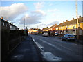
South end of Woodview, Cotgrave
Looking towards the village centre from the junction with Ring Leas.
Image: © Richard Vince
Taken: 24 Feb 2015
0.21 miles
7
Ring Leas
Looking southeast from near Cartbridge. The distant woodland is Cotgrave Gorse.
Image: © Alan Murray-Rust
Taken: 3 Oct 2011
0.22 miles
8
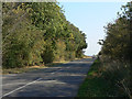
Owthorpe Road
The top of the hill out of Cotgrave.
Image: © Alan Murray-Rust
Taken: 3 Oct 2011
0.22 miles
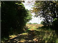
9
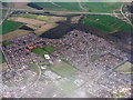
Cotgrave and the A46
Looking east over the eastern edge of the village.
Image: © M J Richardson
Taken: 5 Apr 2016
0.23 miles
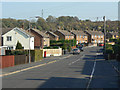
10
Ring Leas, Cotgrave
A distributor road around the southern and eastern sides of the village, serving housing constructed to house miners at Cotgrave Colliery.
Image: © Richard Vince
Taken: 24 Feb 2015
0.23 miles