IMAGES TAKEN NEAR TO
Firdale, NOTTINGHAM, NG12 3NA
Introduction
This page details the photographs taken nearby to Firdale, NG12 3NA by members of the Geograph project.
The Geograph project started in 2005 with the aim of publishing, organising and preserving representative images for every square kilometre of Great Britain, Ireland and the Isle of Man.

There are currently over 7.5m images from over14,400 individuals and you can help contribute to the project by visiting https://www.geograph.org.uk
Image Map
Images are licensed for reuse under creativecommons.org/licenses/by-sa/2.0
Notes
- Clicking on the map will re-center to the selected point.
- The higher the marker number, the further away the image location is from the centre of the postcode.
Image Listing (11 Images Found)
Images are licensed for reuse under creativecommons.org/licenses/by-sa/2.0
Image
Details
Distance
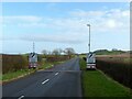
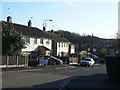
1
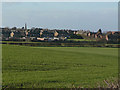
Cotgrave village
The eastern end of the village seen from Colston Gate. Most of this housing resulted from the development of the nearby Cotgrave Colliery, now gone without trace.
Image: © Alan Murray-Rust
Taken: 6 Dec 2009
0.05 miles
2
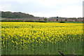
Oil Seed Rape at Cotgrave
Cotgrave was one of the most southerly coal mining villages in the Nottinghamshire coal fields opened in the 1960s. A huge National Coal Board owned housing estate was built to the south and east of the village to accommodate hundreds of "immigrant" miners from the closing Scottish and North Eastern mines. See http://www.minersadvice.co.uk/nottingham.htm
Image: © Kate Jewell
Taken: 30 Apr 2006
0.06 miles
3
Oil Seed Rape at Cotgrave
Recreating this 'First' for the square http://www.geograph.org.uk/photo/161541 complete with original title, although the time of year means that one has to imagine the crop itself!
Image: © Alan Murray-Rust
Taken: 9 Jan 2022
0.13 miles
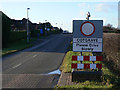
4
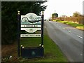
Cotgrave village sign
Cotgrave uses a number of different designs for its signs. This one displays the mining monument of Cotgrave Green https://www.geograph.org.uk/photo/2635770
Image: © Alan Murray-Rust
Taken: 9 Jan 2022
0.14 miles
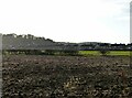
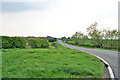
5
Colston Gate, Cotgrave
The boundary of the village looking towards Colston Bassett.
Image: © Alan Murray-Rust
Taken: 9 Jan 2022
0.14 miles
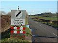
6
Please drive slowly
Better still, don't drive at all! That is the correct meaning of this sign, taken at face value. In fact it is a 30mph restriction sign from which the figures have been stripped.
Image: © Alan Murray-Rust
Taken: 6 Dec 2009
0.15 miles
7
Colston Gate, Cotgrave
The houses on the left are part of the huge NCB built estate.
Image: © Kate Jewell
Taken: 30 Apr 2006
0.15 miles
8
Thank you
This is the reverse face of the sign seen in http://www.geograph.org.uk/photo/1608756.
Image: © Alan Murray-Rust
Taken: 6 Dec 2009
0.16 miles
9
Ring Leas
The main road of the major expansion of the village following the development of the nearby colliery, now gone without trace.
Image: © Alan Murray-Rust
Taken: 6 Dec 2009
0.20 miles
10
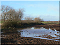
Standing water
The clay soils in this district have not provided good drainage for the previous night's heavy rainfall.
Image: © Alan Murray-Rust
Taken: 6 Dec 2009
0.21 miles