IMAGES TAKEN NEAR TO
Owthorpe Road, NOTTINGHAM, NG12 3JE
Introduction
This page details the photographs taken nearby to Owthorpe Road, NG12 3JE by members of the Geograph project.
The Geograph project started in 2005 with the aim of publishing, organising and preserving representative images for every square kilometre of Great Britain, Ireland and the Isle of Man.

There are currently over 7.5m images from over14,400 individuals and you can help contribute to the project by visiting https://www.geograph.org.uk
Image Map
Images are licensed for reuse under creativecommons.org/licenses/by-sa/2.0
Notes
- Clicking on the map will re-center to the selected point.
- The higher the marker number, the further away the image location is from the centre of the postcode.
Image Listing (14 Images Found)
Images are licensed for reuse under creativecommons.org/licenses/by-sa/2.0
Image
Details
Distance
1
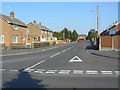
Ring Leas
This is the main distributor road through the large housing development on the south side of Cotgrave built to house workers from the new Cotgrave Colliery which started production in 1964. This is the western end where it joins Owthorpe Road.
Image: © Alan Murray-Rust
Taken: 3 Oct 2011
0.19 miles
2

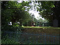
Cotgrave
Looking down the footpath leading into Cotgrave.
Image: © John Everington
Taken: 3 Nov 2006
0.20 miles
3
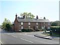
Cottages on Risegate
Close to the modern shopping centre, a reminder that Cotgrave was once a small rural village.
Image: © Alan Murray-Rust
Taken: 3 Oct 2011
0.22 miles
4
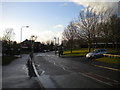
Candleby Lane, Cotgrave
Looking towards the village centre.
Image: © Richard Vince
Taken: 24 Feb 2015
0.23 miles
5
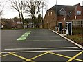
Electric car charging points
In the car park at Rivermead shopping centre. The fact that the view was taken on a Sunday may explain the lack of customers.
Image: © Alan Murray-Rust
Taken: 9 Jan 2022
0.23 miles
7

Cotgrave War Memorial ? detail
Bronze panels on the east face with commemorative details. See http://www.geograph.org.uk/photo/7067779 for location.
Image: © Alan Murray-Rust
Taken: 9 Jan 2022
0.23 miles
8

Cotgrave War Memorial ? detail
This inscription was clearly added at a late stage after the main panel had been prepared. The memorial was unveiled in June 1920. See http://www.geograph.org.uk/photo/7067779 for location.
Image: © Alan Murray-Rust
Taken: 9 Jan 2022
0.23 miles
9

Cotgrave War Memorial
Designed by architect Lt Col Arthur William Brewill (1861-1923) and erected in 1920. There are commemorative panels http://www.geograph.org.uk/photo/7067773 on the far face of the memorial, but the sun was at an inconvenient angle to get the whole monument with the panels. Listed Grade II.
Image: © Alan Murray-Rust
Taken: 9 Jan 2022
0.23 miles
10

Cotgrave Police Station
The village is apparently large enough to justify its continued existence.
Image: © Alan Murray-Rust
Taken: 3 Oct 2011
0.23 miles