IMAGES TAKEN NEAR TO
Swabs Lane, NOTTINGHAM, NG12 3GT
Introduction
This page details the photographs taken nearby to Swabs Lane, NG12 3GT by members of the Geograph project.
The Geograph project started in 2005 with the aim of publishing, organising and preserving representative images for every square kilometre of Great Britain, Ireland and the Isle of Man.

There are currently over 7.5m images from over14,400 individuals and you can help contribute to the project by visiting https://www.geograph.org.uk
Image Map
Images are licensed for reuse under creativecommons.org/licenses/by-sa/2.0
Notes
- Clicking on the map will re-center to the selected point.
- The higher the marker number, the further away the image location is from the centre of the postcode.
Image Listing (43 Images Found)
Images are licensed for reuse under creativecommons.org/licenses/by-sa/2.0
Image
Details
Distance
1
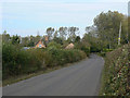
Swab's Lane
With Fishpond Cottage and Fishpond Wood to the left.
Image: © Alan Murray-Rust
Taken: 3 Oct 2011
0.01 miles
2
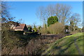
Canal Cottage at Owthorpe
Next to the disused Grantham Canal.
Image: © Mat Fascione
Taken: 24 Nov 2017
0.03 miles
3
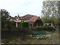
Fishpond Cottage
Beside an abandoned section of the Grantham Canal
Image: © Graham Hogg
Taken: 28 Feb 2017
0.03 miles
4
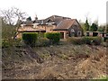
Canalside Cottage
Probably the original cottages, but clearly subject to substantial rebuilding in recent years.
Image: © Alan Murray-Rust
Taken: 3 Oct 2011
0.03 miles
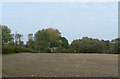
5
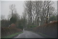
A grim day near Fishpond Wood
Gusts of 108 mph have hit Wales and a Met. Office Red Warning for hurricane force winds is in force, and a cold front is in the process of trundling through this area, making even getting out of the car now too dangerous!
All that in a winter that has been the wettest for about 200 years, with the Somerset levels underwater for nearly two months, and the Thames has burst its banks and is at its highest level for 60 years.
Image: © Chris
Taken: 12 Feb 2014
0.03 miles
6
Grantham Canal at Fishpond Wood
The canal is significantly widened at this point, possibly to provide a winding hole, although there may well have been a wharf serving Owthorpe.
Image: © Alan Murray-Rust
Taken: 3 Oct 2011
0.03 miles
7
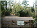
Entrance to Fishpond Wood
This is currently being regenerated as a 17th century garden and wetland/woodland, as established by Colonel Hutchison. See http://www.lhi.org.uk/projects_directory/projects_by_region/east_midlands/nottinghamshire/colonel_hutchisons_garden/index.html
Image: © Alan Murray-Rust
Taken: 3 Oct 2011
0.04 miles
8
The Grantham Canal near Canal Cottage
Almost dry.
Image: © Jonathan Thacker
Taken: 23 Sep 2016
0.05 miles
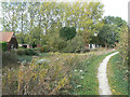
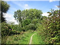
9
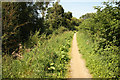
Grantham Canal towpath
Towpath beside the disused Grantham Canal
Image: © Richard Croft
Taken: 3 Sep 2012
0.05 miles
10
Looking towards Canal Cottage
At the Swab's Lane/Park Lane crossroads.
Image: © Alan Murray-Rust
Taken: 3 Oct 2011
0.08 miles