IMAGES TAKEN NEAR TO
Dobbin Close, NOTTINGHAM, NG12 3GR
Introduction
This page details the photographs taken nearby to Dobbin Close, NG12 3GR by members of the Geograph project.
The Geograph project started in 2005 with the aim of publishing, organising and preserving representative images for every square kilometre of Great Britain, Ireland and the Isle of Man.

There are currently over 7.5m images from over14,400 individuals and you can help contribute to the project by visiting https://www.geograph.org.uk
Image Map
Images are licensed for reuse under creativecommons.org/licenses/by-sa/2.0
Notes
- Clicking on the map will re-center to the selected point.
- The higher the marker number, the further away the image location is from the centre of the postcode.
Image Listing (82 Images Found)
Images are licensed for reuse under creativecommons.org/licenses/by-sa/2.0
Image
Details
Distance
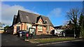
1
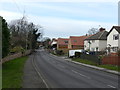
Fern Road, Cropwell Bishop
Cropwell Bishop lies between the Vale of Belvoir and the plain of the River Trent. One mile south of Cropwell Butler and four miles south east of Bingham. It is situated on the east side of the Nottingham to Grantham Canal which passes within a few hundred yards of the village centre.The name of Cropwell is derived from a round hill between the villages of Cropwell Bishop and Cropwell Butler. Cropwell means "with a crop or hump". Located close to the Fosse Way, the village was mentioned in the Domesday survey of 1086. The village is also home to Cropwell Bishop Creamery, famous for its award winning stilton and other fine English cheeses.(Description from the Parish Council web-site).
Image: © Peter Barr
Taken: 7 Feb 2013
0.04 miles
2
The Surgery, Cropwell Bishop, Notts.
The pathway leading up to the local surgery, off Fern Road.
Image: © David Hallam-Jones
Taken: 11 Jan 2014
0.04 miles
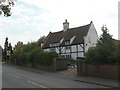
3
The Cottage, Cropwell Bishop
A black & white photograph of this fine cottage is at Image, together with a full description.
Image: © Peter Barr
Taken: 7 Feb 2013
0.05 miles
4
Cropwell Bishop Surgery
The village is lucky enough to support its own doctors' surgery.
Image: © Alan Murray-Rust
Taken: 3 Oct 2011
0.05 miles
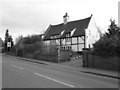
5
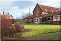
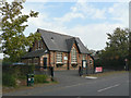
The Old School, now The Cropwell Bishop Community Hub
Now a meeting hall and currently undergoing roof repairs.
For history of the school see; http://cropwellbishop-pc.gov.uk/history-2/
Image: © Chris Morgan
Taken: 7 Feb 2017
0.06 miles
6
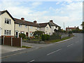
Housing on Fern Hill
A small group of council houses on the east edge of the village.
Image: © Alan Murray-Rust
Taken: 3 Oct 2011
0.06 miles
7
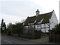
The Cottage, Cropwell Bishop
Timber framed farmhouse, with plastered panels and brick end gables (Grade II listed and listed in Pevsner). Steeply-pitched pantile roof with off-centre ridge stack and brick coped gables on square kneelers. Rectangular 2 room plan. Two Storeys. Box framing with diagonal bracing to wall posts. The oldest part of the house dates to the 1590's, though the majority viewable from the street is later 17th Century. The house would originally have been thatched, as indicated by the tall stack. Renovation in the 1960's revealed a hidden space believed to be a priest hole.
Image: © nmtoken
Taken: 11 Mar 2011
0.06 miles
8
24 Fern Road, Cropwell Bishop
17th century timber-framed house, with plastered infill. The coped gables with square kneelers are typical of the district. Listed Grade II.
(There is apparently dendrochronological evidence that dates the house to the end of the 16th century but I have been unable to verify this; the 17th century date is taken from the listed building text.)
Image: © Alan Murray-Rust
Taken: 3 Oct 2011
0.06 miles
9
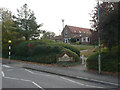
The Old School
Dated 1877 in the central dormer gable. Now in use as a parish meeting hall, additional to the main village hall http://www.geograph.org.uk/photo/2634274.
Image: © Alan Murray-Rust
Taken: 3 Oct 2011
0.07 miles
10
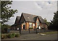
The Old School, Cropwell Bishop
The same view as Image, but you can see the later, 2012, extension in the form of another gable at the rear. A history of the building is at http://cropwellbishop-pc.gov.uk/history-2/ .
Image: © Derek Harper
Taken: 11 Oct 2014
0.07 miles