IMAGES TAKEN NEAR TO
Cropwell Road, NOTTINGHAM, NG12 3GB
Introduction
This page details the photographs taken nearby to Cropwell Road, NG12 3GB by members of the Geograph project.
The Geograph project started in 2005 with the aim of publishing, organising and preserving representative images for every square kilometre of Great Britain, Ireland and the Isle of Man.

There are currently over 7.5m images from over14,400 individuals and you can help contribute to the project by visiting https://www.geograph.org.uk
Image Map
Images are licensed for reuse under creativecommons.org/licenses/by-sa/2.0
Notes
- Clicking on the map will re-center to the selected point.
- The higher the marker number, the further away the image location is from the centre of the postcode.
Image Listing (54 Images Found)
Images are licensed for reuse under creativecommons.org/licenses/by-sa/2.0
Image
Details
Distance
1
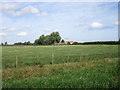
Looking across the Grantham Canal towards Mackley's Farm
Image: © Jonathan Thacker
Taken: 23 Sep 2016
0.02 miles
2
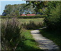
Towpath along the disused Grantham Canal
In the distance is Oddhouse Farm.
Image: © Mat Fascione
Taken: 6 Oct 2013
0.03 miles
4
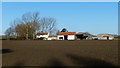
Mackley's Farm viewed from the Grantham Canal towpath
Image: © Mat Fascione
Taken: 24 Nov 2017
0.04 miles
7
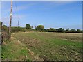
Field between Owthorpe Road and Swab's Lane
Image: © Andrew Tatlow
Taken: 10 Oct 2012
0.17 miles
9
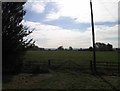
Gate into field by Swab's Lane/Park Lane/Owthorpe Road junction
Image: © Andrew Tatlow
Taken: 10 Oct 2012
0.17 miles
10
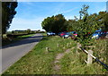
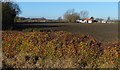
Car park next to Mackley's Bridge and the Grantham Canal
Image: © Mat Fascione
Taken: 6 Oct 2013
0.18 miles