IMAGES TAKEN NEAR TO
Village Street, NOTTINGHAM, NG12 3GA
Introduction
This page details the photographs taken nearby to Village Street, NG12 3GA by members of the Geograph project.
The Geograph project started in 2005 with the aim of publishing, organising and preserving representative images for every square kilometre of Great Britain, Ireland and the Isle of Man.

There are currently over 7.5m images from over14,400 individuals and you can help contribute to the project by visiting https://www.geograph.org.uk
Image Map
Images are licensed for reuse under creativecommons.org/licenses/by-sa/2.0
Notes
- Clicking on the map will re-center to the selected point.
- The higher the marker number, the further away the image location is from the centre of the postcode.
Image Listing (37 Images Found)
Images are licensed for reuse under creativecommons.org/licenses/by-sa/2.0
Image
Details
Distance
1
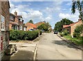
Village Street in Owthorpe
Charming hamlet neatly tucked away with no through road, located to the south-east of Cotgrave.
Image: © Jonathan Clitheroe
Taken: 3 Aug 2024
0.01 miles
2
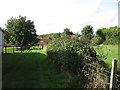
Footpath from the church, Owthorpe
Image: © Jonathan Thacker
Taken: 23 Sep 2016
0.02 miles
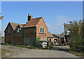
3
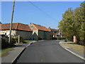
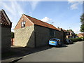
Village Street, Owthorpe
To the left the barns of the former Old Hall Farm, now converted to residential use.
Image: © Alan Murray-Rust
Taken: 3 Oct 2011
0.02 miles
4
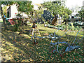
Old farm implements at Owthorpe
Lined up alongside the village street.
Image: © Alan Murray-Rust
Taken: 3 Oct 2011
0.02 miles
5
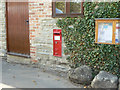
Owthorpe Postbox ref. No. NG12 118
VR wall box inserted in the wall of a barn. The village is too small to have ever had its own post Office.
Image: © Alan Murray-Rust
Taken: 3 Oct 2011
0.02 miles
6
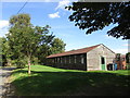
Church Barn, Owthorpe
The village hall.
Image: © Jonathan Thacker
Taken: 23 Sep 2016
0.02 miles
7
Barn conversion, Village Street, Owthorpe
Image: © Jonathan Thacker
Taken: 23 Sep 2016
0.03 miles
8
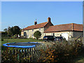
Old Hall Farmhouse
An 18th century farmhouse, later remodelled, built in the typical thin coursed lias limestone of the district. Listed Grade II.
The farm buildings have been converted to residential use.
Image: © Alan Murray-Rust
Taken: 3 Oct 2011
0.04 miles
9
School Farm, Owthorpe
This appears to be the last functioning farm in the village.
Image: © Alan Murray-Rust
Taken: 3 Oct 2011
0.05 miles
10
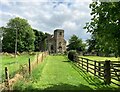
St. Margaret's Church in Owthorpe
Grade II* listed church located slightly to the east of the main settlement and accessible only on foot via this grassy path. Closer inspection from this angle reveals a raised keystone above the doorway, above which are 2 angels holding a shield. A large manor house, Owthorpe Hall, was also located here until it was destroyed by fire in the late 1820s.
Image: © Jonathan Clitheroe
Taken: 3 Aug 2024
0.08 miles