IMAGES TAKEN NEAR TO
West End, NOTTINGHAM, NG12 3EX
Introduction
This page details the photographs taken nearby to West End, NG12 3EX by members of the Geograph project.
The Geograph project started in 2005 with the aim of publishing, organising and preserving representative images for every square kilometre of Great Britain, Ireland and the Isle of Man.

There are currently over 7.5m images from over14,400 individuals and you can help contribute to the project by visiting https://www.geograph.org.uk
Image Map
Images are licensed for reuse under creativecommons.org/licenses/by-sa/2.0
Notes
- Clicking on the map will re-center to the selected point.
- The higher the marker number, the further away the image location is from the centre of the postcode.
Image Listing (19 Images Found)
Images are licensed for reuse under creativecommons.org/licenses/by-sa/2.0
Image
Details
Distance
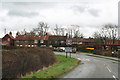
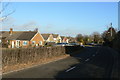
2
Kinoulton Lane entering Kinoulton
Kinoulton = "Farmstead of a woman called Cynehild" https://www.oxfordreference.com/display/10.1093/acref/9780199609086.001.0001/acref-9780199609086;jsessionid=0D59793DC7C317907274406F40F9EC0C
Image: © Tim Heaton
Taken: 8 Dec 2022
0.03 miles
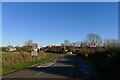
3
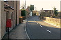
Westend Kinoulton
Westend is the row of cottages on the right and the road meets Main Street
Image: © Tom Courtney
Taken: 18 Sep 2005
0.04 miles
4
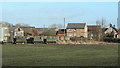
Hollowhill Farm
This marks the western extremity of the village of Kinoulton. The former army vehicles appear to be in current use, but it is not obvious what for.
Image: © Alan Murray-Rust
Taken: 9 Jan 2011
0.04 miles
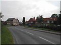
5
Kinoulton, Main Street
The west end of the village, looking west at Ivy Farm. The postbox is ref. NG12 325 Main Street (West End).
Image: © Alan Murray-Rust
Taken: 9 Jan 2011
0.04 miles
6
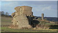
Hay Tor?
This crazy stack of bales is reminiscent of the jumbled stacks of rock of the Dartmoor Tors, like Hay Tor!
Image: © Alan Murray-Rust
Taken: 9 Jan 2011
0.07 miles
7
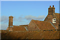
Roofscape at Elm Farm, Kinoulton
A fine selection of traditional brickwork and red pantiles.
Image: © Alan Murray-Rust
Taken: 9 Jan 2011
0.07 miles
8
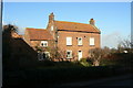
Elm Farm, Kinoulton
One of only three listed buildings in the village of Kinoulton. Late 18th or early 19th century farmhouse in typical vernacular style for the area, with some later additions. Listed Grade II.
Image: © Alan Murray-Rust
Taken: 9 Jan 2011
0.07 miles
9
Kinoulton Main Street
Looking east at Ivy Farm, with some modern housing development.
Image: © Alan Murray-Rust
Taken: 9 Jan 2011
0.12 miles
10
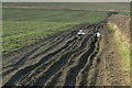
Muddy ruts
This farm track follows the line of a footpath leading up onto the wolds. There was just enough space to avoid having to walk in them.
Image: © Alan Murray-Rust
Taken: 9 Jan 2011
0.14 miles