IMAGES TAKEN NEAR TO
Hickling Lane, NOTTINGHAM, NG12 3ED
Introduction
This page details the photographs taken nearby to Hickling Lane, NG12 3ED by members of the Geograph project.
The Geograph project started in 2005 with the aim of publishing, organising and preserving representative images for every square kilometre of Great Britain, Ireland and the Isle of Man.

There are currently over 7.5m images from over14,400 individuals and you can help contribute to the project by visiting https://www.geograph.org.uk
Image Map
Images are licensed for reuse under creativecommons.org/licenses/by-sa/2.0
Notes
- Clicking on the map will re-center to the selected point.
- The higher the marker number, the further away the image location is from the centre of the postcode.
Image Listing (27 Images Found)
Images are licensed for reuse under creativecommons.org/licenses/by-sa/2.0
Image
Details
Distance
1
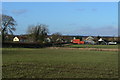
Kinoulton from the south east
New houses are under construction to the right. The white building left is the village cricket pavilion.
Image: © Alan Murray-Rust
Taken: 9 Jan 2011
0.04 miles
2
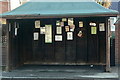
Village notice board
The bus shelter at Kinoulton Green is well used by the local populace as an informal notice board.
Image: © Alan Murray-Rust
Taken: 9 Jan 2011
0.08 miles
4
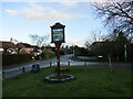
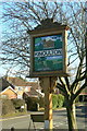
Kinoulton Village Sign (1)
Erected to commemorate the millennium in 2000, and sponsored by the British Legion. There are four different views. On this side the upper panel shows the avenue of poplar trees planted along the drive to Vimy Ridge Farm, and a view on the Grantham Canal, possibly the Devil's Elbow http://www.geograph.org.uk/photo/2228766. For the other side, see http://www.geograph.org.uk/photo/2227783.
Image: © Alan Murray-Rust
Taken: 9 Jan 2011
0.09 miles
5
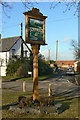
Kinoulton Village Sign (2)
This side shows the parish church and a view looking down from Kinoulton Wolds into the Vale of Belvoir. For the whole sign (from the opposite side) see http://www.geograph.org.uk/photo/2227779.
Image: © Alan Murray-Rust
Taken: 9 Jan 2011
0.09 miles
6
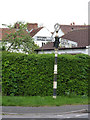
Fingerpost, Hickling Road/Main Street, Kinoulton
A traditional Notts CC cast iron fingerpost with annulus finial.
Image: © Alan Murray-Rust
Taken: 27 Apr 2014
0.09 miles
7
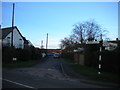
Hall Lane, Kinoulton
Complete with slightly droopy finger post.
Image: © Richard Vince
Taken: 10 Jan 2016
0.09 miles
8
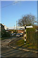
Finger post at Kinoulton
A standard Notts County Council cast post with ring top, still sporting unmodernised fingers.
Image: © Alan Murray-Rust
Taken: 9 Jan 2011
0.09 miles
9
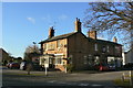
Nevile Arms, Kinoulton
Village pub in Kinoulton, it has the hallmarks of having been developed by the local landowning family, bearing their name as a result.
Image: © Alan Murray-Rust
Taken: 9 Jan 2011
0.10 miles
10
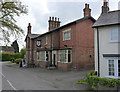
Nevile Arms, Kinoulton
There is a bench mark http://www.geograph.org.uk/photo/3958190 on the near corner, gable wall.
Image: © Alan Murray-Rust
Taken: 27 Apr 2014
0.10 miles